
Carte topographique Pritzwalk
Carte interactive
Cliquez sur la carte pour afficher l’altitude.
À propos de cette carte
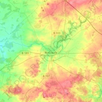
Nom : Carte topographique Pritzwalk, altitude, relief.
Lieu : Pritzwalk, Prignitz, Brandenburg, 16928, Duitsland (53.07251 12.08277 53.23080 12.33209)
Altitude moyenne : 81 m
Altitude minimum : 42 m
Altitude maximum : 127 m
Autres cartes topographiques
Cliquez sur une carte pour visualiser sa topographie, son altitude et son relief.
Helle
Duitsland > Brandenburg > Prignitz > Groß Pankow (Prignitz)
Helle, Groß Pankow (Prignitz), Prignitz, Brandenburg, Duitsland
Altitude moyenne : 55 m