
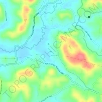
Carte topographique Sreekrishnaswami Temple Pond,Thiruvampady
Carte interactive
Cliquez sur la carte pour afficher l’altitude.
À propos de cette carte
Nom : Carte topographique Sreekrishnaswami Temple Pond,Thiruvampady, altitude, relief.
Altitude moyenne : 30 m
Altitude minimum : 3 m
Altitude maximum : 77 m
Autres cartes topographiques
Cliquez sur une carte pour visualiser sa topographie, son altitude et son relief.
Muvatupuzha
India > Kerala > Vaikom > Velloor
Muvatupuzha, Velloor, Vaikom, Kottayam District, Kerala, India
Altitude moyenne : 14 m
Thalayolaparambu
Thalayolaparambu, Vaikom, Kottayam, Kerala, 686605, India
Altitude moyenne : 10 m
Vembanadu
India > Kerala > Vaikom > Kulangara Colony
Vembanadu, Laksham Veed Colony, Kulangara Colony, Vaikom, Kottayam, Kerala, India
Altitude moyenne : 2 m