
Carte topographique Deans
Cliquez sur la carte pour afficher l’altitude.
À propos de cette carte
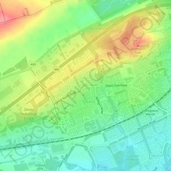
Nom : Carte topographique Deans, altitude, relief.
Lieu : Deans, West Lothian, Scotland, United Kingdom (55.89659 -3.57410 55.91306 -3.54186)
Altitude moyenne : 164 m
Altitude minimum : 128 m
Altitude maximum : 215 m
Autres cartes topographiques
Cliquez sur une carte pour visualiser sa topographie, son altitude et son relief.
Bathgate
United Kingdom > Scotland > West Lothian
In the 1846 book A Topographical Dictionary of Scotland, Samuel Lewis writes.
Altitude moyenne : 167 m
Armadale
United Kingdom > Scotland > West Lothian
Aside from the presence of the old castle, Armadale was little more than a rural farm community for most of its history, as part of a larger rural estate named Barbauchlaw (a corruption of 'Boar Baughlee'). However, this situation changed with the coming of the new turnpike road between Edinburgh and Glasgow…
Altitude moyenne : 166 m
Bathgate
United Kingdom > Scotland > West Lothian
In the 1846 book A Topographical Dictionary of Scotland, Samuel Lewis writes.
Altitude moyenne : 167 m