
Faire un don
Équipez-vous pour votre prochaine aventure :
En tant que Partenaire Amazon, ce site perçoit une commission sur les achats éligibles sans surcoût pour vous.
Carte topographique Glastonbury
Cliquez sur la carte pour afficher l’altitude.
Faire un don
Équipez-vous pour votre prochaine aventure :
En tant que Partenaire Amazon, ce site perçoit une commission sur les achats éligibles sans surcoût pour vous.
Glastonbury
Glastonbury, Connecticut, features a diverse topography characterized by its location along the eastern banks of the Connecticut River, where the terrain begins at a low elevation near the river and gradually ascends into rolling hills. The town encompasses notable elevations such as Kongscut Mountain and Minnechaug Mountain, with peaks reaching around 800 feet. These higher areas provide scenic views of the Hartford skyline and are complemented by regions of dense woodlands, including the expansive Meshomasic State Forest, which is popular for outdoor activities like hiking and fishing.
Faire un don
Équipez-vous pour votre prochaine aventure :
En tant que Partenaire Amazon, ce site perçoit une commission sur les achats éligibles sans surcoût pour vous.
À propos de cette carte
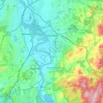
Nom : Carte topographique Glastonbury, altitude, relief.
Altitude moyenne : 67 m
Altitude minimum : 0 m
Altitude maximum : 273 m
Faire un don
Équipez-vous pour votre prochaine aventure :
En tant que Partenaire Amazon, ce site perçoit une commission sur les achats éligibles sans surcoût pour vous.
Autres cartes topographiques
Cliquez sur une carte pour visualiser sa topographie, son altitude et son relief.
West Suffield
United States > Connecticut > Capitol Planning Region > Suffield
Altitude moyenne : 59 m
Plantsville
United States > Connecticut > Capitol Planning Region > Southington
Altitude moyenne : 57 m
Four Corners
United States > Connecticut > Capitol Planning Region > Terramuggus
Altitude moyenne : 143 m
Willington Hill
United States > Connecticut > Capitol Planning Region > Willington
Altitude moyenne : 197 m
Faire un don
Équipez-vous pour votre prochaine aventure :
En tant que Partenaire Amazon, ce site perçoit une commission sur les achats éligibles sans surcoût pour vous.
Griswoldville
United States > Connecticut > Capitol Planning Region > Wethersfield
Altitude moyenne : 34 m
Faire un don
Équipez-vous pour votre prochaine aventure :
En tant que Partenaire Amazon, ce site perçoit une commission sur les achats éligibles sans surcoût pour vous.
Chaffeeville
United States > Connecticut > Capitol Planning Region > Mansfield
Altitude moyenne : 133 m
West District
United States > Connecticut > Capitol Planning Region > Farmington
Altitude moyenne : 92 m
Talcott Mountain
United States > Connecticut > Capitol Planning Region > Bloomfield
Altitude moyenne : 152 m
Faire un don
Équipez-vous pour votre prochaine aventure :
En tant que Partenaire Amazon, ce site perçoit une commission sur les achats éligibles sans surcoût pour vous.
South Wethersfield
United States > Connecticut > Capitol Planning Region > Wethersfield > Griswoldville
Altitude moyenne : 22 m
Buckingham
United States > Connecticut > Capitol Planning Region > Glastonbury
Altitude moyenne : 131 m
North Coventry
United States > Connecticut > Capitol Planning Region > Coventry
Altitude moyenne : 195 m
Faire un don
Équipez-vous pour votre prochaine aventure :
En tant que Partenaire Amazon, ce site perçoit une commission sur les achats éligibles sans surcoût pour vous.
Bishop's Corner
United States > Connecticut > Capitol Planning Region > West Hartford
Altitude moyenne : 47 m
Talcott Mountain
United States > Connecticut > Capitol Planning Region > Bloomfield
Altitude moyenne : 152 m
Johnson Hill
United States > Connecticut > Capitol Planning Region > West Hartford
Altitude moyenne : 34 m
Faire un don
Équipez-vous pour votre prochaine aventure :
En tant que Partenaire Amazon, ce site perçoit une commission sur les achats éligibles sans surcoût pour vous.
Faire un don
Équipez-vous pour votre prochaine aventure :
En tant que Partenaire Amazon, ce site perçoit une commission sur les achats éligibles sans surcoût pour vous.
Holcomb Farm
United States > Connecticut > Capitol Planning Region > Granby > West Granby
Altitude moyenne : 116 m
Faire un don
Équipez-vous pour votre prochaine aventure :
En tant que Partenaire Amazon, ce site perçoit une commission sur les achats éligibles sans surcoût pour vous.
Spoonville
United States > Connecticut > Capitol Planning Region > East Granby
Altitude moyenne : 62 m
Stafford Springs
United States > Connecticut > Capitol Planning Region > Stafford
Altitude moyenne : 200 m
Faire un don
Équipez-vous pour votre prochaine aventure :
En tant que Partenaire Amazon, ce site perçoit une commission sur les achats éligibles sans surcoût pour vous.
Cottage Grove
United States > Connecticut > Capitol Planning Region > Bloomfield
Altitude moyenne : 31 m
Barbara Drive
United States > Connecticut > Capitol Planning Region > Windsor Locks
Altitude moyenne : 39 m
Faire un don
Équipez-vous pour votre prochaine aventure :
En tant que Partenaire Amazon, ce site perçoit une commission sur les achats éligibles sans surcoût pour vous.