
Faire un don
Équipez-vous pour votre prochaine aventure :
En tant que Partenaire Amazon, ce site perçoit une commission sur les achats éligibles sans surcoût pour vous.
Carte topographique Monroe County
Cliquez sur la carte pour afficher l’altitude.
Faire un don
Équipez-vous pour votre prochaine aventure :
En tant que Partenaire Amazon, ce site perçoit une commission sur les achats éligibles sans surcoût pour vous.
Monroe County
According to the Trewartha climate classification system, the higher elevation Pocono Plateau Region of Monroe County has a Temperate Continental climate (Dc) with warm summers (b), cold winters (o) and year-around precipitation (Dcbo). Dcbo climates are characterized by at least one month having an average mean temperature ≤ 32.0 °F (0.0 °C), four to seven months with an average mean temperature ≥ 50.0 °F (10.0 °C), all months with an average mean temperature < 72.0 °F (22.2 °C) and no significant precipitation difference between seasons. Although most summer days are comfortably humid on the Pocono Plateau, episodes of heat and high humidity can occur with heat index values > 92 °F (33 °C). Since 1981, the highest air temperature was 93.0 °F (33.9 °C) on July 15, 1995, and the highest daily average mean dew point was 70.8 °F (21.6 °C) on January 8, 2006. July is the peak month for thunderstorm activity which correlates with the average warmest month of the year. Since 1981, the wettest calendar day was 6.43 inches (163 mm) on September 30, 2010. During the winter months, the plant hardiness zone is 5b with an average annual extreme minimum air temperature of −11.2 °F (−24.0 °C). Since 1981, the coldest air temperature was −22.9 °F (−30.5 °C) on January 21, 1994. Episodes of extreme cold and wind can occur with wind chill values < −24 °F (−31 °C). The average snowiest month is January which correlates with the average coldest month of the year. Ice storms and large snowstorms depositing ≥ 12 inches (30 cm) of snow occur nearly every year, particularly during nor’easters from December through March.
Faire un don
Équipez-vous pour votre prochaine aventure :
En tant que Partenaire Amazon, ce site perçoit une commission sur les achats éligibles sans surcoût pour vous.
À propos de cette carte
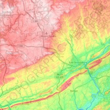
Nom : Carte topographique Monroe County, altitude, relief.
Lieu : Monroe County, Pennsylvania, United States (40.81484 -75.64929 41.25213 -74.96660)
Altitude moyenne : 361 m
Altitude minimum : 56 m
Altitude maximum : 684 m
Faire un don
Équipez-vous pour votre prochaine aventure :
En tant que Partenaire Amazon, ce site perçoit une commission sur les achats éligibles sans surcoût pour vous.
Autres cartes topographiques
Cliquez sur une carte pour visualiser sa topographie, son altitude et son relief.
Rosewood Park
United States > Pennsylvania > Bucks County > Warminster Township
Altitude moyenne : 88 m
Sunny Rest Lodge
United States > Pennsylvania > Carbon County > Franklin Township
Altitude moyenne : 237 m
Wood
United States > Pennsylvania > Bucks County > Bristol Township > Levittown
Altitude moyenne : 15 m
Frazer
United States > Pennsylvania > Chester County > East Whiteland Township
Altitude moyenne : 142 m
Faire un don
Équipez-vous pour votre prochaine aventure :
En tant que Partenaire Amazon, ce site perçoit une commission sur les achats éligibles sans surcoût pour vous.
Cornwells Heights
United States > Pennsylvania > Bucks County > Bensalem Township
Altitude moyenne : 16 m
Faire un don
Équipez-vous pour votre prochaine aventure :
En tant que Partenaire Amazon, ce site perçoit une commission sur les achats éligibles sans surcoût pour vous.
Feasterville
United States > Pennsylvania > Bucks County > Lower Southampton Township
Altitude moyenne : 66 m
Glenrose
United States > Pennsylvania > Chester County > East Fallowfield Township
Altitude moyenne : 154 m
Faire un don
Équipez-vous pour votre prochaine aventure :
En tant que Partenaire Amazon, ce site perçoit une commission sur les achats éligibles sans surcoût pour vous.
Warminster Heights
United States > Pennsylvania > Bucks County > Warminster Township
Altitude moyenne : 86 m
Gardenville
United States > Pennsylvania > Bucks County > Plumstead Township > Gardenville
Altitude moyenne : 134 m
Faire un don
Équipez-vous pour votre prochaine aventure :
En tant que Partenaire Amazon, ce site perçoit une commission sur les achats éligibles sans surcoût pour vous.
Lima
United States > Pennsylvania > Delaware County > Middletown Township > Lima
Altitude moyenne : 93 m