
Carte topographique Norman
Carte interactive
Cliquez sur la carte pour afficher l’altitude.
À propos de cette carte
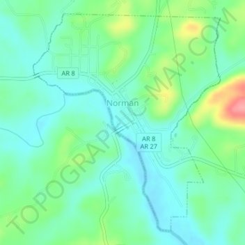
Nom : Carte topographique Norman, altitude, relief.
Lieu : Norman, Montgomery County, Arkansas, 71960, United States (34.44248 -93.69358 34.46648 -93.66851)
Altitude moyenne : 227 m
Altitude minimum : 201 m
Altitude maximum : 294 m
Autres cartes topographiques
Cliquez sur une carte pour visualiser sa topographie, son altitude et son relief.
Joplin
United States > Arkansas > Montgomery County
Joplin, Montgomery County, Arkansas, United States
Altitude moyenne : 231 m
Ophir
United States > Arkansas > Montgomery County
Ophir, Montgomery County, Arkansas, United States
Altitude moyenne : 238 m
Sims
United States > Arkansas > Montgomery County
Sims, Montgomery County, Arkansas, 71969, United States
Altitude moyenne : 227 m
Mount Ida
United States > Arkansas > Montgomery County
Mount Ida, Montgomery County, Arkansas, United States
Altitude moyenne : 215 m
Mount Ida
United States > Arkansas > Montgomery County > Mount Ida
Mount Ida, Montgomery County, Arkansas, United States
Altitude moyenne : 215 m
Mount Ida
United States > Arkansas > Montgomery County > Mount Ida > Mount Ida
Mount Ida, Montgomery County, Arkansas, United States
Altitude moyenne : 216 m