
Faire un don
Équipez-vous pour votre prochaine aventure :
En tant que Partenaire Amazon, ce site perçoit une commission sur les achats éligibles sans surcoût pour vous.
Carte topographique Auberry
Cliquez sur la carte pour afficher l’altitude.
Faire un don
Équipez-vous pour votre prochaine aventure :
En tant que Partenaire Amazon, ce site perçoit une commission sur les achats éligibles sans surcoût pour vous.
Auberry
Auberry (/ˈɔːbɛri/) is a census-designated place (CDP) in Fresno County, California, United States. The population was 2,369 at the 2010 census, up from 2,053 at the 2000 census. Auberry is located on Little Sandy Creek 9.5 miles (15 km) west of Shaver Lake Heights, at an elevation of 2,018 feet (615 m).
Faire un don
Équipez-vous pour votre prochaine aventure :
En tant que Partenaire Amazon, ce site perçoit une commission sur les achats éligibles sans surcoût pour vous.
À propos de cette carte
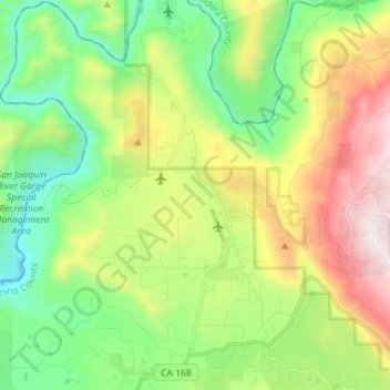
Nom : Carte topographique Auberry, altitude, relief.
Altitude moyenne : 611 m
Altitude minimum : 165 m
Altitude maximum : 1 390 m
Faire un don
Équipez-vous pour votre prochaine aventure :
En tant que Partenaire Amazon, ce site perçoit une commission sur les achats éligibles sans surcoût pour vous.