
Carte topographique Peiting
Cliquez sur la carte pour afficher l’altitude.
À propos de cette carte
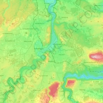
Nom : Carte topographique Peiting, altitude, relief.
Altitude moyenne : 742 m
Altitude minimum : 613 m
Altitude maximum : 985 m
Autres cartes topographiques
Cliquez sur une carte pour visualiser sa topographie, son altitude et son relief.
Weilheim in Oberbayern
Deutschland > Bayern > Landkreis Weilheim-Schongau > Weilheim in Oberbayern
Altitude moyenne : 584 m
Rameck
Deutschland > Bayern > Landkreis Weilheim-Schongau > Huglfing > Huglfing > Rameck
Altitude moyenne : 621 m
Hoher Peißenberg
Deutschland > Bayern > Landkreis Weilheim-Schongau > Hohenpeißenberg
Der Hohe Peißenberg gehört in der naturräumlichen Haupteinheitengruppe Subalpines Jungmoränenland (Nr. 03), in der Haupteinheit Ammer-Loisach-Isar-Jungmoränenland (037) und in der Untereinheit Hügel- und Moorland des Ammersees (037.0) zum Naturraum Peißenbergkämme (037.09). Seine Landschaft fällt etwa…
Altitude moyenne : 810 m
Lexe
Deutschland > Bayern > Landkreis Weilheim-Schongau > Peiting > Herzogsägmühle
Altitude moyenne : 715 m
Vogelfreistätte Ammersee-Südufer
Deutschland > Bayern > Landkreis Weilheim-Schongau > Aidenried
Altitude moyenne : 536 m
Deutenhausen
Deutschland > Bayern > Landkreis Weilheim-Schongau > Weilheim in Oberbayern
Altitude moyenne : 608 m
Ficht
Deutschland > Bayern > Landkreis Weilheim-Schongau > Peißenberg > Ficht
Altitude moyenne : 586 m
Steinfall
Deutschland > Bayern > Landkreis Weilheim-Schongau > Hohenpeißenberg
Altitude moyenne : 743 m