
Faire un don
Équipez-vous pour votre prochaine aventure :
En tant que Partenaire Amazon, ce site perçoit une commission sur les achats éligibles sans surcoût pour vous.
Carte topographique Port Jefferson
Cliquez sur la carte pour afficher l’altitude.
Faire un don
Équipez-vous pour votre prochaine aventure :
En tant que Partenaire Amazon, ce site perçoit une commission sur les achats éligibles sans surcoût pour vous.
Port Jefferson
It wasn't until 1836 that the local leadership truly initiated the community's transition from a swampish hamlet to a bustling port town. Twenty-two acres of the harborfront, which flooded with the tides, were brought to a stable elevation with the construction of a causeway. Concurrently, the village was rechristened from "Drowned Meadow" to "Port Jefferson" The name choice was in honor of Thomas Jefferson.
Faire un don
Équipez-vous pour votre prochaine aventure :
En tant que Partenaire Amazon, ce site perçoit une commission sur les achats éligibles sans surcoût pour vous.
À propos de cette carte
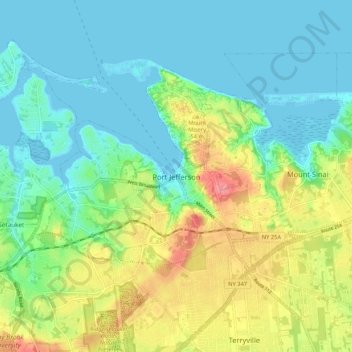
Nom : Carte topographique Port Jefferson, altitude, relief.
Altitude moyenne : 26 m
Altitude minimum : -4 m
Altitude maximum : 82 m
Faire un don
Équipez-vous pour votre prochaine aventure :
En tant que Partenaire Amazon, ce site perçoit une commission sur les achats éligibles sans surcoût pour vous.