
Carte topographique Blanca Peak
Carte interactive
Cliquez sur la carte pour afficher l’altitude.
À propos de cette carte
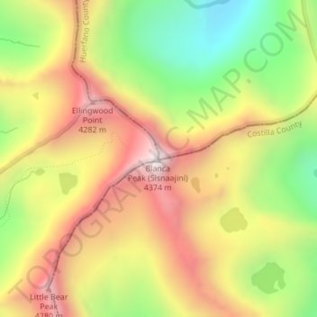
Nom : Carte topographique Blanca Peak, altitude, relief.
Lieu : Blanca Peak, Alamosa County, Colorado, United States (37.57756 -105.48558 37.57766 -105.48548)
Altitude moyenne : 3 871 m
Altitude minimum : 3 347 m
Altitude maximum : 4 363 m
Blanca Peak is notable not only for its absolute height, but also for its great local relief and dominant position at the end of the range, rising high above the San Luis Valley to the west. For example, it rises nearly 7,000 feet (2,100 m) over the edge of the San Luis Valley in only 6 miles (9.7 km). Blanca is also the third most topographically prominent peak in Colorado; it is separated from the higher peaks in the Sawatch Range by relatively low Poncha Pass at 9,019 feet (2,749 m).
Autres cartes topographiques
Cliquez sur une carte pour visualiser sa topographie, son altitude et son relief.
Lake Como
United States > Colorado > Alamosa County
Lake Como, Alamosa County, Colorado, United States
Altitude moyenne : 3 718 m