
Faire un don
Équipez-vous pour votre prochaine aventure :
En tant que Partenaire Amazon, ce site perçoit une commission sur les achats éligibles sans surcoût pour vous.
Carte topographique Patapsco River
Cliquez sur la carte pour afficher l’altitude.
Faire un don
Équipez-vous pour votre prochaine aventure :
En tant que Partenaire Amazon, ce site perçoit une commission sur les achats éligibles sans surcoût pour vous.
Patapsco River
The Patapsco River mainstem begins at the confluence of the North and South Branches, near Marriottsville, approximately 15 miles (24 km) west of downtown Baltimore. The 19.4-mile-long (31.2 km)[1] South Branch rises further west at Parr's Spring, where Howard County, Carroll, Frederick, and Montgomery counties meet. The latter begins at elevation 780 feet (240 m) on Parr's Ridge, just south of Interstate 70 and east of Ridge Road (Highway 27), 2 miles (3 km) south of Mount Airy, Maryland.[1] The South Branch Patapsco River traces the southern boundary of Carroll County and the northern boundary of Howard County. The first land record regarding Parr's Springs dates from 1744, when John Parr laid out a 200 acres (81 ha) tract he called Parr's Range. During the Civil War, Parr's Spring was a stop for the Army of the Potomac's Brig. Gen. David M. Gregg's cavalry, on June 29, 1863, while en route to Gettysburg, Pennsylvania.[9] Parr's Spring was dug to form a 1.75 acres (7,100 m2) pond in the 1950s, filled by seven spring heads that form the headwaters of the South Branch of the Patapsco River.[10]
Faire un don
Équipez-vous pour votre prochaine aventure :
En tant que Partenaire Amazon, ce site perçoit une commission sur les achats éligibles sans surcoût pour vous.
À propos de cette carte
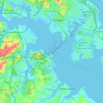
Nom : Carte topographique Patapsco River, altitude, relief.
Altitude moyenne : 7 m
Altitude minimum : -7 m
Altitude maximum : 51 m
Faire un don
Équipez-vous pour votre prochaine aventure :
En tant que Partenaire Amazon, ce site perçoit une commission sur les achats éligibles sans surcoût pour vous.
Autres cartes topographiques
Cliquez sur une carte pour visualiser sa topographie, son altitude et son relief.
Orchard Beach
United States > Maryland > Anne Arundel County > Riviera Beach > Orchard Beach
Altitude moyenne : 6 m