
Faire un don
Équipez-vous pour votre prochaine aventure :
En tant que Partenaire Amazon, ce site perçoit une commission sur les achats éligibles sans surcoût pour vous.
Carte topographique LaSalle
Cliquez sur la carte pour afficher l’altitude.
Faire un don
Équipez-vous pour votre prochaine aventure :
En tant que Partenaire Amazon, ce site perçoit une commission sur les achats éligibles sans surcoût pour vous.
À propos de cette carte
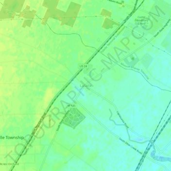
Nom : Carte topographique LaSalle, altitude, relief.
Lieu : LaSalle, Monroe County, Michigan, 48145, United States (41.84782 -83.47216 41.88782 -83.43216)
Altitude moyenne : 183 m
Altitude minimum : 175 m
Altitude maximum : 190 m
Faire un don
Équipez-vous pour votre prochaine aventure :
En tant que Partenaire Amazon, ce site perçoit une commission sur les achats éligibles sans surcoût pour vous.
Autres cartes topographiques
Cliquez sur une carte pour visualiser sa topographie, son altitude et son relief.
Monroe
United States > Michigan > Monroe County
According to the United States Census Bureau, the city has a total area of 10.18 square miles (26.37 km2), of which 9.17 square miles (23.75 km2) is land and 1.01 square miles (2.62 km2) (9.92%) is water. Monroe sits at the lowest elevation in state of Michigan, which is the shores of Lake Erie at 571 feet…
Altitude moyenne : 182 m
Frenchtown Charter Township
United States > Michigan > Monroe County
The township is in eastern Monroe County and is bordered to the southeast by Lake Erie. Many of the township's communities are located near the lake. Sterling State Park is located along the southern edge of the township and is the only Michigan state park on Lake Erie. Small pieces of the township are…
Altitude moyenne : 181 m
Faire un don
Équipez-vous pour votre prochaine aventure :
En tant que Partenaire Amazon, ce site perçoit une commission sur les achats éligibles sans surcoût pour vous.
Faire un don
Équipez-vous pour votre prochaine aventure :
En tant que Partenaire Amazon, ce site perçoit une commission sur les achats éligibles sans surcoût pour vous.
River Raisin
United States > Michigan > Monroe County > Raisinville Township > Grape
Altitude moyenne : 192 m
Faire un don
Équipez-vous pour votre prochaine aventure :
En tant que Partenaire Amazon, ce site perçoit une commission sur les achats éligibles sans surcoût pour vous.
Frenchtown Charter Township
United States > Michigan > Monroe County
The township is in eastern Monroe County and is bordered to the southeast by Lake Erie. Many of the township's communities are located near the lake. Sterling State Park is located along the southern edge of the township and is the only Michigan state park on Lake Erie. Small pieces of the township are…
Altitude moyenne : 181 m
Monroe
United States > Michigan > Monroe County
Monroe is in eastern Monroe County, with its city limits extending southeast3 miles (5 km) from the downtown to Lake Erie. The average elevation of the city is 594 feet (181 metres), decreasing to 571 feet (174 metres) at Lake Erie, which sits at the lowest elevation in Michigan. The Port of Monroe is the only…
Altitude moyenne : 182 m
Frenchtown Charter Township
United States > Michigan > Monroe County
The township is in eastern Monroe County and is bordered to the southeast by Lake Erie. Many of the township's communities are located near the lake. Sterling State Park is located along the southern edge of the township and is the only Michigan state park on Lake Erie. Small pieces of the township are…
Altitude moyenne : 181 m
Faire un don
Équipez-vous pour votre prochaine aventure :
En tant que Partenaire Amazon, ce site perçoit une commission sur les achats éligibles sans surcoût pour vous.