
Faire un don
Équipez-vous pour votre prochaine aventure :
En tant que Partenaire Amazon, ce site perçoit une commission sur les achats éligibles sans surcoût pour vous.
Carte topographique Washougal
Cliquez sur la carte pour afficher l’altitude.
Faire un don
Équipez-vous pour votre prochaine aventure :
En tant que Partenaire Amazon, ce site perçoit une commission sur les achats éligibles sans surcoût pour vous.
À propos de cette carte
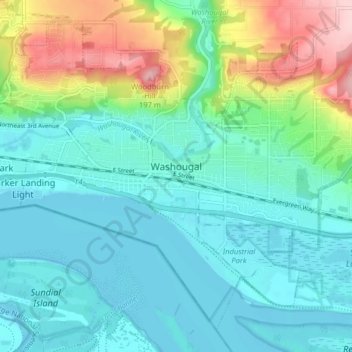
Nom : Carte topographique Washougal, altitude, relief.
Lieu : Washougal, Clark County, Washington, United States (45.55590 -122.38609 45.60488 -122.30616)
Altitude moyenne : 50 m
Altitude minimum : 0 m
Altitude maximum : 207 m
Faire un don
Équipez-vous pour votre prochaine aventure :
En tant que Partenaire Amazon, ce site perçoit une commission sur les achats éligibles sans surcoût pour vous.
Autres cartes topographiques
Cliquez sur une carte pour visualiser sa topographie, son altitude et son relief.
Lake River
United States > Washington > Clark County > Ridgefield
Lake River, a "slow, flat slough of the Columbia River", loses only 1 foot (30 cm) in elevation over its entire 11-mile (18 km) course. It flows north, roughly parallel to the Columbia until curving slightly northwest to join it. At times, tidal fluctuations and high flows along the Columbia cause Lake River…
Altitude moyenne : 35 m
Salmon Creek Regional Park
United States > Washington > Clark County > Vancouver
Altitude moyenne : 48 m
Faire un don
Équipez-vous pour votre prochaine aventure :
En tant que Partenaire Amazon, ce site perçoit une commission sur les achats éligibles sans surcoût pour vous.
Faire un don
Équipez-vous pour votre prochaine aventure :
En tant que Partenaire Amazon, ce site perçoit une commission sur les achats éligibles sans surcoût pour vous.