
Faire un don
Équipez-vous pour votre prochaine aventure :
En tant que Partenaire Amazon, ce site perçoit une commission sur les achats éligibles sans surcoût pour vous.
Carte topographique Newry
Cliquez sur la carte pour afficher l’altitude.
Faire un don
Équipez-vous pour votre prochaine aventure :
En tant que Partenaire Amazon, ce site perçoit une commission sur les achats éligibles sans surcoût pour vous.
Newry
At 20:15 on June 27, 1960, a United States Air Force tanker of the 380th Air Refueling Squadron departed Plattsburgh AFB to refuel a Strategic Air Command bomber. The Boeing KC-97 Stratofreighter rendezvoused with the B-47 Stratojet bomber at an altitude of 15,500 feet in the Fighting Fox aerial refueling area over Newry. As the bomber maneuvered into refueling position, a lubrication failure caused the tanker's outboard port engine supercharger impeller to disintegrate. Impeller fragments leaving the engine nacelle caused fuel leakage. The bomber observed ignition of the leaking fuel and broke away from formation. The tanker entered a gradual left turn, which became a spiraling spin as the fire rapidly caused structural damage to the port wing. Seven miles away, three hundred people at a Rumford Point drive-in theater observed the tanker spin down, with burning pieces flying off. The fuselage impacted a forested slope of granite boulders and caused a fireball seen fifty miles away in Lewiston. The port wing tip was found in Howard Pond, three miles from the crash site. There were no survivors from the tanker's five-man crew. Wet vegetation limited spread of the fire, but fuel-covered trees were completely consumed and the five-acre hillside wreckage field was discernible for years amid the surrounding forest.
Faire un don
Équipez-vous pour votre prochaine aventure :
En tant que Partenaire Amazon, ce site perçoit une commission sur les achats éligibles sans surcoût pour vous.
À propos de cette carte
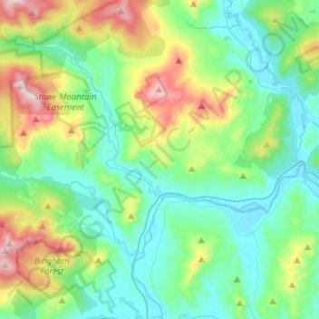
Nom : Carte topographique Newry, altitude, relief.
Lieu : Newry, Oxford County, Maine, 04261, United States (44.41796 -70.90423 44.59692 -70.70428)
Altitude moyenne : 392 m
Altitude minimum : 183 m
Altitude maximum : 1 019 m
Faire un don
Équipez-vous pour votre prochaine aventure :
En tant que Partenaire Amazon, ce site perçoit une commission sur les achats éligibles sans surcoût pour vous.
Autres cartes topographiques
Cliquez sur une carte pour visualiser sa topographie, son altitude et son relief.
Sturtevant Pond
United States > Maine > Oxford County > Magalloway Plantation
Altitude moyenne : 406 m
Mad River Falls
United States > Maine > Oxford County > Batchelders Grant Township
Altitude moyenne : 495 m
Faire un don
Équipez-vous pour votre prochaine aventure :
En tant que Partenaire Amazon, ce site perçoit une commission sur les achats éligibles sans surcoût pour vous.