Géolocaliser

Carte topographique Laleham

Cliquez sur la carte pour afficher l’altitude.

À propos de cette carte

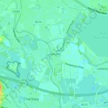
Nom : Carte topographique Laleham, altitude, relief.

Lieu : Laleham, Borough of Spelthorne, Surrey, England, TW18 1SD, United Kingdom (51.38890 -0.51027 51.42890 -0.47027)

Altitude moyenne : 14 m

Altitude minimum : 7 m

Altitude maximum : 44 m

Autres cartes topographiques

Cliquez sur une carte pour visualiser sa topographie, son altitude et son relief.

Shepperton

United Kingdom > England > Surrey > Borough of Spelthorne

Shepperton has a long boundary with the River Thames in its southernmost salient, which almost surrounds Spelthorne. Old Shepperton is almost surrounded by the extreme southern meander within this. Prehistoric glacial retreat north of this has made the north bank almost flat for a considerable distance and as…

Altitude moyenne : 12 m

Ashford

United Kingdom > England > Surrey > Borough of Spelthorne

Altitude moyenne : 16 m

Shepperton

United Kingdom > England > Surrey > Borough of Spelthorne

Shepperton has a long boundary with the River Thames in its southernmost salient, which almost surrounds Spelthorne. Old Shepperton is almost surrounded by the extreme southern meander within this. Prehistoric glacial retreat north of this has made the north bank almost flat for a considerable distance and as…

Altitude moyenne : 12 m

Équipez-vous pour votre prochaine aventure :

🦶Crème Anti-Frottements - Prévient les irritations cutanées lors de longues marches.
🗡️Couteaux outdoor - Couteaux polyvalents pour randonnée et camping
🧤Gants de Randonnée - Gants légers et tactiles pour manipuler vos cartes par temps froid.
🩹Trousse de Secours - L'essentiel pour soigner les petits bobos en sentier.
📍GPS de randonnée - GPS portables pour navigation précise en milieu naturel

En tant que Partenaire Amazon, ce site perçoit une commission sur les achats éligibles sans surcoût pour vous.