
Carte topographique Upper Swainswick
Carte interactive
Cliquez sur la carte pour afficher l’altitude.
À propos de cette carte
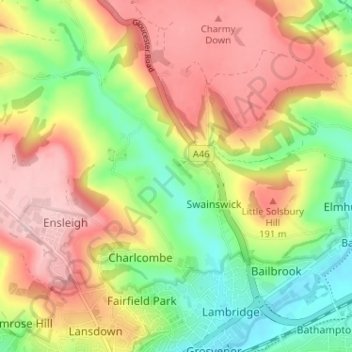
Nom : Carte topographique Upper Swainswick, altitude, relief.
Altitude moyenne : 124 m
Altitude minimum : 16 m
Altitude maximum : 235 m
Autres cartes topographiques
Cliquez sur une carte pour visualiser sa topographie, son altitude et son relief.
Tadwick
United Kingdom > England > Bath and North East Somerset > Swainswick
Tadwick, Swainswick, Bath and North East Somerset, West of England, England, BA1 8AH, United Kingdom
Altitude moyenne : 161 m