Géolocaliser

Carte topographique Ironbridge

Cliquez sur la carte pour afficher l’altitude.

À propos de cette carte

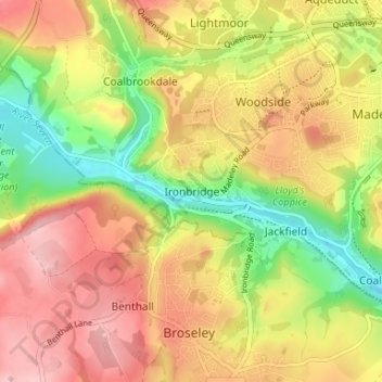
Nom : Carte topographique Ironbridge, altitude, relief.

Lieu : Ironbridge, Telford and Wrekin, England, TF8 7AA, United Kingdom (52.60813 -2.50224 52.64813 -2.46224)

Altitude moyenne : 126 m

Altitude minimum : 37 m

Altitude maximum : 201 m

Autres cartes topographiques

Cliquez sur une carte pour visualiser sa topographie, son altitude et son relief.

Edgmond

United Kingdom > England > Telford and Wrekin > Edgmond

Altitude moyenne : 73 m

Wellington

United Kingdom > England > Telford and Wrekin

Altitude moyenne : 93 m

Ketley

United Kingdom > England > Telford and Wrekin > Telford

Altitude moyenne : 127 m

Madeley

United Kingdom > England > Telford and Wrekin

Altitude moyenne : 116 m

Play Park

United Kingdom > England > Telford and Wrekin > Dawley

Altitude moyenne : 176 m

Kynnersley

United Kingdom > England > Telford and Wrekin

Altitude moyenne : 57 m

Madeley

United Kingdom > England > Telford and Wrekin

Altitude moyenne : 116 m

Edgmond

United Kingdom > England > Telford and Wrekin > Edgmond

Altitude moyenne : 73 m

Madeley

United Kingdom > England > Telford and Wrekin

Altitude moyenne : 116 m

Madeley

United Kingdom > England > Telford and Wrekin

Altitude moyenne : 116 m

Équipez-vous pour votre prochaine aventure :

🧼Savon Biodégradable - Respectez l'environnement lors de vos toilettes en nature.
🧳Sacs de voyage outdoor - Sacs résistants pour voyages nature
🔥Réchauds de camping - Réchauds compacts pour cuisine en plein air
☀️Crème Solaire Sport - Haute protection qui résiste à la transpiration.
📱Supports smartphone vélo - Navigation mobile sécurisée

En tant que Partenaire Amazon, ce site perçoit une commission sur les achats éligibles sans surcoût pour vous.