
Faire un don
Équipez-vous pour votre prochaine aventure :
En tant que Partenaire Amazon, ce site perçoit une commission sur les achats éligibles sans surcoût pour vous.
Carte topographique Muztagh Ata
Cliquez sur la carte pour afficher l’altitude.
Faire un don
Équipez-vous pour votre prochaine aventure :
En tant que Partenaire Amazon, ce site perçoit une commission sur les achats éligibles sans surcoût pour vous.
Muztagh Ata
Muztagh Ata (meaning 'Ice Mountain Father' in English), formerly known as Mount Tagharma and Wi-tagh, is the second highest of the mountains which form the northern edge of the Tibetan Plateau, with an elevation of 7,546 m (24,757 ft). It is sometimes regarded as being part of the Kunlun Mountains, although physically it is more closely connected to the Pamirs. It is one of the relatively easier 7,000 m peaks in the world to climb, due to its gentle western slope and the comparatively drier weather of Xinjiang, though a thorough acclimatization period and a very strong physical condition are crucial for success.
Faire un don
Équipez-vous pour votre prochaine aventure :
En tant que Partenaire Amazon, ce site perçoit une commission sur les achats éligibles sans surcoût pour vous.
À propos de cette carte
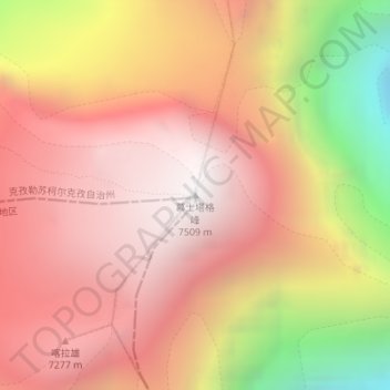
Nom : Carte topographique Muztagh Ata, altitude, relief.
Altitude moyenne : 6 786 m
Altitude minimum : 5 449 m
Altitude maximum : 7 520 m
Faire un don
Équipez-vous pour votre prochaine aventure :
En tant que Partenaire Amazon, ce site perçoit une commission sur les achats éligibles sans surcoût pour vous.
Autres cartes topographiques
Cliquez sur une carte pour visualiser sa topographie, son altitude et son relief.