
Carte topographique Errol
Carte interactive
Cliquez sur la carte pour afficher l’altitude.
À propos de cette carte
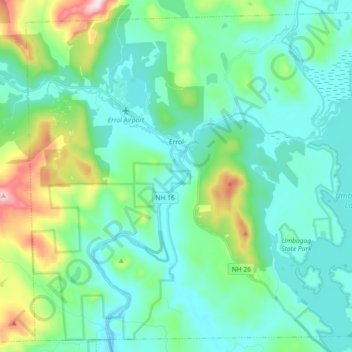
Nom : Carte topographique Errol, altitude, relief.
Lieu : Errol, Coös County, New Hampshire, United States (44.70826 -71.21592 44.82853 -71.03441)
Altitude moyenne : 453 m
Altitude minimum : 358 m
Altitude maximum : 821 m
According to the United States Census Bureau, the town has a total area of 69.5 square miles (179.9 km2), of which 60.3 square miles (156.3 km2) are land and 9.1 square miles (23.5 km2) are water, comprising 13.09% of the town. The Androscoggin River begins in Errol, where the Magalloway River joins the outlet of Umbagog Lake. The town's elevation reaches 2,350 feet (720 m) above sea level atop a bump above Signal Pond near the town's western boundary. Errol lies fully within the Androscoggin River watershed.
Autres cartes topographiques
Cliquez sur une carte pour visualiser sa topographie, son altitude et son relief.
Holden Hill
United States > New Hampshire > Coos County > Stewartstown
Holden Hill, Stewartstown, Coös County, New Hampshire, United States
Altitude moyenne : 660 m
Upper Village
United States > New Hampshire > Coos County > Gorham
Upper Village, Gorham, Coös County, New Hampshire, 03581, United States
Altitude moyenne : 343 m
Success
United States > New Hampshire > Coos County
Success, Coos County, New Hampshire, United States
Altitude moyenne : 565 m
Lombard Pond
United States > New Hampshire > Coos County > Colebrook
Lombard Pond, Colebrook, Coos County, New Hampshire, United States
Altitude moyenne : 402 m