
Carte topographique Bompensiere
Carte interactive
Cliquez sur la carte pour afficher l’altitude.
Bompensiere
The town is arranged along a single main street on whose sides the houses are divided, almost uniformly distributed. The lowest point of the town is to the north-west, at an altitude of about 270 meters above sea level (Piana Giarre); the highest point is located in the south-east at an altitude of about 320 meters above sea level (Contrada Portella).
À propos de cette carte
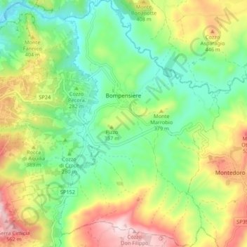
Nom : Carte topographique Bompensiere, altitude, relief.
Lieu : Bompensiere, Caltanissetta, Sicily, 93010, Italy (37.43393 13.75927 37.49893 13.81269)
Altitude moyenne : 319 m
Altitude minimum : 154 m
Altitude maximum : 583 m