
Faire un don
Équipez-vous pour votre prochaine aventure :
En tant que Partenaire Amazon, ce site perçoit une commission sur les achats éligibles sans surcoût pour vous.
Carte topographique Begusarai
Cliquez sur la carte pour afficher l’altitude.
Faire un don
Équipez-vous pour votre prochaine aventure :
En tant que Partenaire Amazon, ce site perçoit une commission sur les achats éligibles sans surcoût pour vous.
Begusarai
Begusarai is located at 25°25′N 86°08′E / 25.42°N 86.13°E / 25.42; 86.13. It has an average elevation of 41 metres (134 feet). Begusarai lies in North Bihar and is surrounded by Khagaria in the northeast, Munger in the southeast, Patna in the west, and Samastipur in the northwest.
Faire un don
Équipez-vous pour votre prochaine aventure :
En tant que Partenaire Amazon, ce site perçoit une commission sur les achats éligibles sans surcoût pour vous.
À propos de cette carte
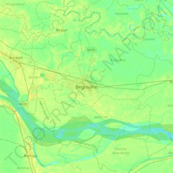
Nom : Carte topographique Begusarai, altitude, relief.
Lieu : Begusarai, Bihar, 851117, India (25.25391 85.97488 25.57391 86.29488)
Altitude moyenne : 41 m
Altitude minimum : 32 m
Altitude maximum : 55 m
Faire un don
Équipez-vous pour votre prochaine aventure :
En tant que Partenaire Amazon, ce site perçoit une commission sur les achats éligibles sans surcoût pour vous.