Géolocaliser

Carte topographique Castletown

Cliquez sur la carte pour afficher l’altitude.

À propos de cette carte

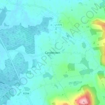
Nom : Carte topographique Castletown, altitude, relief.

Lieu : Castletown, The Municipal District of Mullingar — Kinnegad, County Westmeath, Leinster, A82 F8D2, Ireland (53.73419 -7.35172 53.77419 -7.31172)

Altitude moyenne : 88 m

Altitude minimum : 62 m

Altitude maximum : 239 m

Autres cartes topographiques

Cliquez sur une carte pour visualiser sa topographie, son altitude et son relief.

Ballynacarrigy

Ireland > County Westmeath

Altitude moyenne : 71 m

Ballymore

Ireland > County Westmeath

Altitude moyenne : 81 m

Lough Ennell

Ireland > County Westmeath

Altitude moyenne : 86 m

Lough Derravaragh

Ireland > County Westmeath

Altitude moyenne : 85 m

Lough Lene

Ireland > County Westmeath

The lake is described in Samuel Lewis's Topographical Dictionary of Ireland (1837) as being an irregular oval shape, possibly 3.2 km (2.0 mi) long by 1.7 km (1.1 mi) broad. A fresh water lake, most sources focus on the clarity of the water, with the term "gin clear" being used to describe it. It sits…

Altitude moyenne : 109 m

Raharney

Ireland > County Westmeath

Altitude moyenne : 79 m

Kilbeggan

Ireland > County Westmeath

Altitude moyenne : 71 m

Gallstown

Ireland > County Westmeath

Altitude moyenne : 92 m

Knockmant

Ireland > County Westmeath

Altitude moyenne : 96 m

Nure Bog

Ireland > County Westmeath

Altitude moyenne : 85 m

Kilbeggan

Ireland > County Westmeath

Altitude moyenne : 71 m

Portlick

Ireland > County Westmeath

Altitude moyenne : 46 m

Lough Derravaragh

Ireland > County Westmeath

Altitude moyenne : 85 m

Knockdrin

Ireland > County Westmeath

Altitude moyenne : 98 m

Silver

Ireland > County Westmeath

Altitude moyenne : 67 m

Delvin

Ireland > County Westmeath

Altitude moyenne : 89 m

Clondardis

Ireland > County Westmeath

Altitude moyenne : 112 m

River Brosna

Ireland > County Westmeath > Mullingar

Altitude moyenne : 100 m

Nahod More

Ireland > County Westmeath

Altitude moyenne : 89 m

Ballymore

Ireland > County Westmeath

Altitude moyenne : 81 m

Simonstown

Ireland > County Westmeath

Altitude moyenne : 112 m

Clonkill

Ireland > County Westmeath

Altitude moyenne : 115 m

Lough Sheever

Ireland > County Westmeath

Altitude moyenne : 98 m

Collinstown

Ireland > County Westmeath

Altitude moyenne : 108 m

Kinnegad

Ireland > County Westmeath

Altitude moyenne : 75 m

Multyfarnham

Ireland > County Westmeath

Altitude moyenne : 81 m

Battstown

Ireland > County Westmeath

Altitude moyenne : 94 m

Collinstown

Ireland > County Westmeath

Altitude moyenne : 108 m

Silver

Ireland > County Westmeath

Altitude moyenne : 67 m

Rathconrath

Ireland > County Westmeath

Altitude moyenne : 121 m

Ballymore

Ireland > County Westmeath

Altitude moyenne : 83 m

Rathconrath

Ireland > County Westmeath

Altitude moyenne : 121 m

Athlone

Ireland > County Westmeath

Altitude moyenne : 43 m

Lough Bane

Ireland > County Westmeath

Altitude moyenne : 130 m

Hiskinstown

Ireland > County Westmeath

Altitude moyenne : 85 m

Street

Ireland > County Westmeath

Altitude moyenne : 73 m

Dungolman River

Ireland > County Westmeath

Altitude moyenne : 58 m

Ballyloughloe

Ireland > County Westmeath

Altitude moyenne : 72 m

Kilbixy

Ireland > County Westmeath

Altitude moyenne : 67 m

Athlone

Ireland > County Westmeath

Altitude moyenne : 43 m

Castletown Geoghegan

Ireland > County Westmeath

Altitude moyenne : 96 m

Dysart

Ireland > County Westmeath

Altitude moyenne : 84 m

Tyrrellspass

Ireland > County Westmeath

Altitude moyenne : 100 m

Lough Sewdy

Ireland > County Westmeath

Altitude moyenne : 86 m

Ardnurcher

Ireland > County Westmeath

Altitude moyenne : 71 m

Toberclare

Ireland > County Westmeath

Altitude moyenne : 62 m

Moate

Ireland > County Westmeath

Altitude moyenne : 76 m

Rochfortbridge

Ireland > County Westmeath

Altitude moyenne : 90 m

Lough Bane

Ireland > County Westmeath

Altitude moyenne : 66 m

Glassan

Ireland > County Westmeath

Altitude moyenne : 57 m

Banagher

Ireland > County Westmeath

Altitude moyenne : 96 m

Castlelost

Ireland > County Westmeath

Altitude moyenne : 93 m

Kinnegad

Ireland > County Westmeath > Kinnegad

Altitude moyenne : 75 m

Kiltoom

Ireland > County Westmeath

Altitude moyenne : 80 m

Muckanagh

Ireland > County Westmeath

Altitude moyenne : 38 m

Milltown

Ireland > County Westmeath

Altitude moyenne : 84 m

Simonstown

Ireland > County Westmeath > Simonstown

Altitude moyenne : 80 m

Clonmoyle

Ireland > County Westmeath

Altitude moyenne : 108 m

Kilbeggan

Ireland > County Westmeath

Altitude moyenne : 71 m

Clonmore

Ireland > County Westmeath

Altitude moyenne : 54 m

Griffinstown

Ireland > County Westmeath

Altitude moyenne : 83 m

Paslicktown

Ireland > County Westmeath

Altitude moyenne : 104 m

Balrath

Ireland > County Westmeath

Altitude moyenne : 128 m

Ballykilroe

Ireland > County Westmeath

Altitude moyenne : 89 m

Ballynaskeagh

Ireland > County Westmeath

Altitude moyenne : 90 m

Adamstown

Ireland > County Westmeath

Altitude moyenne : 128 m

Mullingar

Ireland > County Westmeath

Altitude moyenne : 99 m

Garrycastle

Ireland > County Westmeath

Altitude moyenne : 49 m

Équipez-vous pour votre prochaine aventure :

📦Sacs de Compression - Optimisez l'espace et gardez vos vêtements au sec.
🛌Sac de Couchage - Isolation thermique performante pour vos nuits en altitude.
🛡️Casque de VTT - Protection indispensable pour vos descentes en forêt.
📍GPS de randonnée - GPS portables pour navigation précise en milieu naturel
🧦Chaussettes mérinos - Isolation naturelle et respirante

En tant que Partenaire Amazon, ce site perçoit une commission sur les achats éligibles sans surcoût pour vous.