Géolocaliser

Carte topographique Irchester

Cliquez sur la carte pour afficher l’altitude.

Irchester

The 12th-century English historian Henry of Huntingdon mentions a Roman "town on the river (Nene), in Huntingdonshire, which is entirely destroyed" as one of his interpretations of the 28 cities of Britain. The town is mentioned also by William Lambarde in Dictionarium Angliae Topographicum & Historicum.

Wikipedia (CC-BY-SA 3.0)

À propos de cette carte

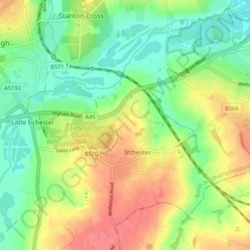
Nom : Carte topographique Irchester, altitude, relief.

Lieu : Irchester, North Northamptonshire, England, United Kingdom (52.26827 -0.68572 52.30521 -0.61055)

Altitude moyenne : 62 m

Altitude minimum : 32 m

Altitude maximum : 98 m

Autres cartes topographiques

Cliquez sur une carte pour visualiser sa topographie, son altitude et son relief.

Corby

United Kingdom > England > North Northamptonshire

Altitude moyenne : 103 m

Laxton

United Kingdom > England > North Northamptonshire

Altitude moyenne : 86 m

Dingley

United Kingdom > England > North Northamptonshire

Altitude moyenne : 110 m

Lowick

United Kingdom > England > North Northamptonshire

Altitude moyenne : 57 m

Pipewell

United Kingdom > England > North Northamptonshire

Altitude moyenne : 124 m

Rushton

United Kingdom > England > North Northamptonshire

Altitude moyenne : 112 m

Slade

United Kingdom > England > North Northamptonshire > Orton

Altitude moyenne : 123 m

Corby

United Kingdom > England > North Northamptonshire

Altitude moyenne : 103 m

Équipez-vous pour votre prochaine aventure :

📷Caméra d'Action - Filmez vos descentes et vos explorations de terrain.
🛏️Sacs de couchage - Sacs de couchage adaptés aux nuits en extérieur
🧢Casquettes sport - Protection solaire respirante
📚Guides de randonnée - Livres de parcours et itinéraires
🧥Veste de Pluie (Hardshell) - Protection contre les intempéries pour rester au sec sur le terrain.

En tant que Partenaire Amazon, ce site perçoit une commission sur les achats éligibles sans surcoût pour vous.