Carte topographique Edneyville
Carte interactive
Cliquez sur la carte pour afficher l’altitude.
À propos de cette carte
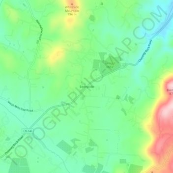
Nom : Carte topographique Edneyville, altitude, relief.
Lieu : Edneyville, Henderson County, North Carolina, United States (35.37401 -82.36095 35.41401 -82.32095)
Altitude moyenne : 689 m
Altitude minimum : 604 m
Altitude maximum : 869 m
Edneyville is in northeastern Henderson County at an elevation of 2,246 feet (685 m) above sea level. The Eastern Continental Divide runs through the center of the CDP; the eastern side of the community drains via Reedypatch Creek to the Broad River, which flows through the Congaree and Santee River systems to the Atlantic Ocean, while the western side of the community drains to Clear Creek, which flows via Mud Creek to the French Broad River, then the Tennessee River, and finally the Mississippi River to the Gulf of Mexico.
Autres cartes topographiques
Cliquez sur une carte pour visualiser sa topographie, son altitude et son relief.
Hendersonville
United States > North Carolina > Henderson County
Hendersonville, Henderson County, North Carolina, 28738, United States
Altitude moyenne : 669 m
Bat Cave
United States > North Carolina > Henderson County
Bat Cave, Henderson County, North Carolina, 28710, United States
Altitude moyenne : 648 m
Horse Shoe
United States > North Carolina > Henderson County
Horse Shoe, Henderson County, North Carolina, 28729, United States
Altitude moyenne : 668 m
Dana
United States > North Carolina > Henderson County
Dana, Henderson County, North Carolina, 28724, United States
Altitude moyenne : 669 m
Laurel Park
United States > North Carolina > Henderson County
Laurel Park, Henderson County, North Carolina, United States
Altitude moyenne : 710 m
Mountain Home
United States > North Carolina > Henderson County
Mountain Home, Henderson County, North Carolina, 28758, United States
Altitude moyenne : 654 m
Mills River
United States > North Carolina > Henderson County > Mills River > Oak Hill Court
Mills River, Oak Hill Court, Mills River, Henderson County, North Carolina, 28759, United States
Altitude moyenne : 633 m
Flat Rock
United States > North Carolina > Henderson County
Flat Rock, Henderson County, North Carolina, United States
Altitude moyenne : 702 m
East Flat Rock
United States > North Carolina > Henderson County > Ridgeview Estates
East Flat Rock, Ridgeview Estates, Henderson County, North Carolina, United States
Altitude moyenne : 655 m
Blue Ridge
United States > North Carolina > Henderson County
Blue Ridge, Henderson County, North Carolina, 28724, United States
Altitude moyenne : 675 m
Mountain Page
United States > North Carolina > Henderson County
Mountain Page, Henderson County, North Carolina, 28773, United States
Altitude moyenne : 675 m
Barker Heights
United States > North Carolina > Henderson County > Barker Heights
Barker Heights, Henderson County, North Carolina, United States
Altitude moyenne : 643 m
Forge Mountain
United States > North Carolina > Henderson County
Forge Mountain, Henderson County, North Carolina, 28742, United States
Altitude moyenne : 753 m
Valley Hill
United States > North Carolina > Henderson County > Lakewood
Valley Hill, Lakewood, Henderson County, North Carolina, 28739, United States
Altitude moyenne : 711 m
Hoopers Creek
United States > North Carolina > Henderson County > Fletcher
Hoopers Creek, Fletcher, Henderson County, North Carolina, 28732, United States
Altitude moyenne : 677 m
Jeter Mountain
United States > North Carolina > Henderson County
Jeter Mountain, Henderson County, North Carolina, 28708, United States
Altitude moyenne : 843 m
Naples
United States > North Carolina > Henderson County
Naples, Henderson County, North Carolina, 28760, United States
Altitude moyenne : 653 m
Glassy Mountain
United States > North Carolina > Henderson County > Flat Rock
Glassy Mountain, Flat Rock, Henderson County, North Carolina, 28726, United States
Altitude moyenne : 718 m
Gerton
United States > North Carolina > Henderson County
Gerton, Henderson County, North Carolina, 28735, United States
Altitude moyenne : 964 m
Zirconia
United States > North Carolina > Henderson County
Zirconia, Henderson County, North Carolina, 28731, United States
Altitude moyenne : 681 m
Fletcher
United States > North Carolina > Henderson County
Fletcher, Henderson County, North Carolina, 28732, United States
Altitude moyenne : 666 m
Bearwallow Mountain
United States > North Carolina > Henderson County
Bearwallow Mountain, Henderson County, North Carolina, 28735, United States
Altitude moyenne : 1 040 m
Wildwood Heights
United States > North Carolina > Henderson County > Laurel Park
Wildwood Heights, Laurel Park, Henderson County, North Carolina, 28739, United States
Altitude moyenne : 757 m
Mills River
United States > North Carolina > Henderson County > Mills River
Mills River, Henderson County, North Carolina, United States
Altitude moyenne : 686 m
Barnwell Mountain
United States > North Carolina > Henderson County
Barnwell Mountain, Henderson County, North Carolina, 28710, United States
Altitude moyenne : 725 m
Cunningham Mountain
United States > North Carolina > Henderson County
Cunningham Mountain, Henderson County, North Carolina, 28760, United States
Altitude moyenne : 728 m
Mills River
United States > North Carolina > Henderson County > Mills River > Oak Hill Court
Mills River, Oak Hill Court, Mills River, Henderson County, North Carolina, 28759, United States
Altitude moyenne : 644 m
Etowah
United States > North Carolina > Henderson County > Etowah
Etowah, Henderson County, North Carolina, United States
Altitude moyenne : 652 m
Carolina Village
United States > North Carolina > Henderson County > Hendersonville > Carolina Village
Carolina Village, Hendersonville, Henderson County, North Carolina, 28738, United States
Altitude moyenne : 650 m
Tuxedo
United States > North Carolina > Henderson County
Tuxedo, Henderson County, North Carolina, 28790, United States
Altitude moyenne : 691 m
Balfour
United States > North Carolina > Henderson County
Balfour, Henderson County, North Carolina, United States
Altitude moyenne : 661 m