
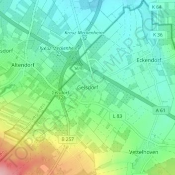
Carte topographique Gelsdorf
Carte interactive
Cliquez sur la carte pour afficher l’altitude.
À propos de cette carte
Nom : Carte topographique Gelsdorf, altitude, relief.
Altitude moyenne : 223 m
Altitude minimum : 181 m
Altitude maximum : 335 m
Autres cartes topographiques
Cliquez sur une carte pour visualiser sa topographie, son altitude et son relief.
Vettelhoven
Deutschland > Rheinland-Pfalz > Landkreis Ahrweiler > Grafschaft
Vettelhoven, Grafschaft, Landkreis Ahrweiler, Rheinland-Pfalz, 53507, Deutschland
Altitude moyenne : 242 m
Holzweiler
Deutschland > Rheinland-Pfalz > Landkreis Ahrweiler > Grafschaft
Holzweiler, Grafschaft, Landkreis Ahrweiler, Rheinland-Pfalz, 53507, Deutschland
Altitude moyenne : 256 m
Bölingen
Deutschland > Rheinland-Pfalz > Landkreis Ahrweiler > Grafschaft > Bölingen
Bölingen, Grafschaft, Landkreis Ahrweiler, Rheinland-Pfalz, 53501, Deutschland
Altitude moyenne : 226 m