
Faire un don
Équipez-vous pour votre prochaine aventure :
En tant que Partenaire Amazon, ce site perçoit une commission sur les achats éligibles sans surcoût pour vous.
Carte topographique Rishikesh
Cliquez sur la carte pour afficher l’altitude.
Faire un don
Équipez-vous pour votre prochaine aventure :
En tant que Partenaire Amazon, ce site perçoit une commission sur les achats éligibles sans surcoût pour vous.
Rishikesh
Rishikesh is at 30°06′12″N 78°17′41″E / 30.103368°N 78.294754°E / 30.103368; 78.294754. It has an average elevation of 372 metres (1,220 ft). The town is located in the Tehri Garhwal region of the northern Indian state of Uttarakhand.
Faire un don
Équipez-vous pour votre prochaine aventure :
En tant que Partenaire Amazon, ce site perçoit une commission sur les achats éligibles sans surcoût pour vous.
À propos de cette carte
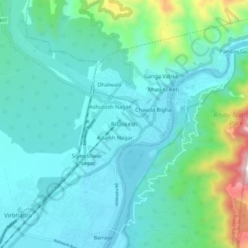
Nom : Carte topographique Rishikesh, altitude, relief.
Lieu : Rishikesh, Dehradun, Uttarakhand, 249201, India (30.06865 78.25162 30.14865 78.33162)
Altitude moyenne : 497 m
Altitude minimum : 323 m
Altitude maximum : 1 363 m
Faire un don
Équipez-vous pour votre prochaine aventure :
En tant que Partenaire Amazon, ce site perçoit une commission sur les achats éligibles sans surcoût pour vous.