
Faire un don
Équipez-vous pour votre prochaine aventure :
En tant que Partenaire Amazon, ce site perçoit une commission sur les achats éligibles sans surcoût pour vous.
Carte topographique Herkimer
Cliquez sur la carte pour afficher l’altitude.
Faire un don
Équipez-vous pour votre prochaine aventure :
En tant que Partenaire Amazon, ce site perçoit une commission sur les achats éligibles sans surcoût pour vous.
Herkimer
In 1722, in response to a request by the German Palatine leaders Joseph Petrie and Conrad Rickert, Governor William Burnet granted the Palatines a lease to purchase land from the Mohawk Nation in the vicinity of the confluence of West Canada Creek and the Mohawk River. After a survey of the land was completed in 1723, many more settlers arrived in the area between 1723 and 1725. They settled on both the north and south sides of the Mohawk River. The area was originally known as "Burnetsfield", named in honor of the governor. The Burnetsfield Patent, granted April 13, 1725, assigned 100-acre (0.40 km2) lots to about ninety heads of family. The area was also referred to at times as "Stone Ridge", "The Flats", "The Falls", and most commonly, due to the mostly German immigrant population and the flat floodplain topography, as German Flatts. This was the first European-American settlement this far west in the Mohawk Valley.
Faire un don
Équipez-vous pour votre prochaine aventure :
En tant que Partenaire Amazon, ce site perçoit une commission sur les achats éligibles sans surcoût pour vous.
À propos de cette carte
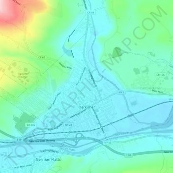
Nom : Carte topographique Herkimer, altitude, relief.
Altitude moyenne : 154 m
Altitude minimum : 110 m
Altitude maximum : 325 m
Faire un don
Équipez-vous pour votre prochaine aventure :
En tant que Partenaire Amazon, ce site perçoit une commission sur les achats éligibles sans surcoût pour vous.