
Faire un don
Équipez-vous pour votre prochaine aventure :
En tant que Partenaire Amazon, ce site perçoit une commission sur les achats éligibles sans surcoût pour vous.
Carte topographique Los Navalucillos
Cliquez sur la carte pour afficher l’altitude.
Faire un don
Équipez-vous pour votre prochaine aventure :
En tant que Partenaire Amazon, ce site perçoit une commission sur les achats éligibles sans surcoût pour vous.
Los Navalucillos
El clima es mediterráneo continental, por su altitud y su lejanía respecto al mar. Los termómetros oscilan entre los 25'3ºC de julio y los 5'7ºC de enero, siendo la temperatura media anual de 14'4ºC.
Faire un don
Équipez-vous pour votre prochaine aventure :
En tant que Partenaire Amazon, ce site perçoit une commission sur les achats éligibles sans surcoût pour vous.
À propos de cette carte
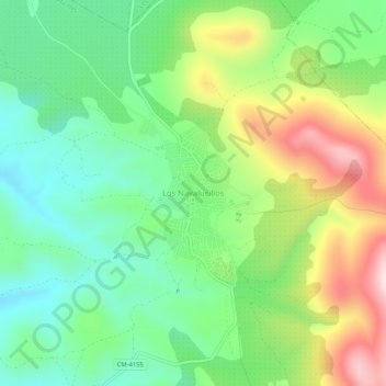
Nom : Carte topographique Los Navalucillos, altitude, relief.
Altitude moyenne : 771 m
Altitude minimum : 626 m
Altitude maximum : 1 024 m
Faire un don
Équipez-vous pour votre prochaine aventure :
En tant que Partenaire Amazon, ce site perçoit une commission sur les achats éligibles sans surcoût pour vous.