
Carte topographique Village of Williamsville
Carte interactive
Cliquez sur la carte pour afficher l’altitude.
À propos de cette carte
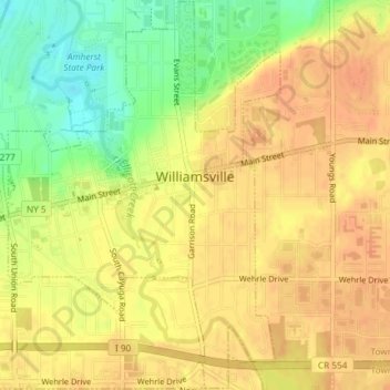
Nom : Carte topographique Village of Williamsville, altitude, relief.
Altitude moyenne : 206 m
Altitude minimum : 181 m
Altitude maximum : 217 m
Autres cartes topographiques
Cliquez sur une carte pour visualiser sa topographie, son altitude et son relief.
North Bailey
United States > New York > Erie County > Town of Amherst
North Bailey, Town of Amherst, Erie County, New York, 14261, United States
Altitude moyenne : 182 m
Swormville
United States > New York > Erie County > Town of Amherst
Swormville, Town of Amherst, Erie County, New York, 14051, United States
Altitude moyenne : 180 m
Getzville
United States > New York > Erie County > Town of Amherst
Getzville, Town of Amherst, Erie County, New York, 14068, United States
Altitude moyenne : 179 m