
Carte topographique Gatton
Cliquez sur la carte pour afficher l’altitude.
Gatton
Gatton's elevations range from 215m AOD, the highest elevation, along Fort Lane, a cul-de-sac off the intersection of Reigate Hill (M25 Junction 8) which leads to four homes over the boundary in Reigate, a radio transmitter station, and a water tower. On the A217 is the Bridge House Hotel, whose name refers to a footbridge carrying the North Downs Way across the A217 85m to the east.
À propos de cette carte
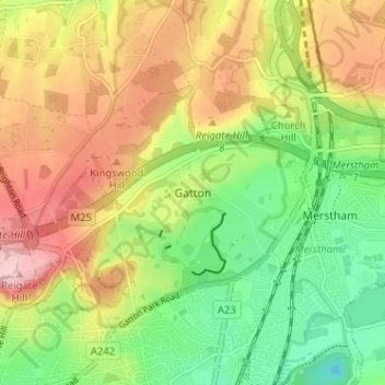
Nom : Carte topographique Gatton, altitude, relief.
Altitude moyenne : 134 m
Altitude minimum : 46 m
Altitude maximum : 236 m
Autres cartes topographiques
Cliquez sur une carte pour visualiser sa topographie, son altitude et son relief.
Lower Earlswood Lake
United Kingdom > England > Surrey > Reigate and Banstead > Redhill
Altitude moyenne : 75 m
Redhill Common
United Kingdom > England > Surrey > Reigate and Banstead > Redhill
Altitude moyenne : 92 m
Banstead Wood
United Kingdom > England > Surrey > Reigate and Banstead > Chipstead
Altitude moyenne : 145 m
Reigate Park
United Kingdom > England > Surrey > Reigate and Banstead > Reigate
Altitude moyenne : 80 m
Horley
United Kingdom > England > Surrey > Reigate and Banstead
Horley is at an altitude of around 54 m (177 ft) above mean sea level.
Altitude moyenne : 58 m