
Carte topographique Warwick
Carte interactive
Cliquez sur la carte pour afficher l’altitude.
À propos de cette carte
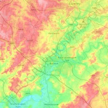
Nom : Carte topographique Warwick, altitude, relief.
Lieu : Warwick, Warwickshire, England, United Kingdom (52.21370 -1.78018 52.38928 -1.40608)
Altitude moyenne : 87 m
Altitude minimum : 35 m
Altitude maximum : 145 m
Warwick experiences the usual English maritime climate, marked by a narrow temperature range, mild winters and cool summers. The nearest official Met Office weather station is at Wellesbourne, about 6 miles (10 km) south of the town centre and at a similar elevation. The absolute maximum temperature (also the absolute maximum for the county of Warwickshire) stands at 36.1 °C (97.0 °F) recorded in August 1990. During a typical year, the warmest day should reach 30.0 °C (86.0 °F), and 16.5 days should report a maximum of 25.1 °C (77.2 °F) or higher. The lowest recorded temperature is −17.8 °C (0.0 °F), recorded in January 1982. Typically, 53.3 air frosts are recorded in an "average" year. Rainfall averages out at 608 millimetres (23.9 in) per year, with over 114 days seeing 1 mm (0.04 in) or more falling. All averages refer to the 1971–2000 period.
Autres cartes topographiques
Cliquez sur une carte pour visualiser sa topographie, son altitude et son relief.
Clifton upon Dunsmore CP
United Kingdom > England > Warwickshire > Rugby
Clifton upon Dunsmore CP, Rugby, Warwickshire, England, United Kingdom
Altitude moyenne : 108 m
Draycote Water
United Kingdom > England > Warwickshire > Rugby > Draycote
Draycote Water, Draycote, Rugby, Warwickshire, England, United Kingdom
Altitude moyenne : 92 m
Harbury
United Kingdom > England > Warwickshire > Stratford-on-Avon
Harbury, Stratford-on-Avon, Warwickshire, England, United Kingdom
Altitude moyenne : 95 m
Binton
United Kingdom > England > Warwickshire > Stratford-on-Avon
Binton, Stratford-on-Avon, Warwickshire, England, CV37 9TL, United Kingdom
Altitude moyenne : 60 m
Burton Dassett Hills Country Park
United Kingdom > England > Warwickshire > Stratford-on-Avon > Northend > Burton Dassett CP
Burton Dassett Hills Country Park, Burton Dassett CP, Northend, Stratford-on-Avon, Warwickshire, England, United Kingdom
Altitude moyenne : 132 m
Alveston
United Kingdom > England > Warwickshire > Stratford-on-Avon
Alveston, Stratford-on-Avon, Warwickshire, England, CV37 7QT, United Kingdom
Altitude moyenne : 50 m
Rugby
United Kingdom > England > Warwickshire
Rugby, Warwickshire, England, United Kingdom
Altitude moyenne : 112 m
Alcester
United Kingdom > England > Warwickshire > Stratford-on-Avon
Alcester, Stratford-on-Avon, Warwickshire, England, United Kingdom
Altitude moyenne : 62 m
Nuneaton
United Kingdom > England > Warwickshire > Nuneaton and Bedworth
Nuneaton, Nuneaton and Bedworth, Warwickshire, England, CV11 5AB, United Kingdom
Altitude moyenne : 101 m
Warmington CP
United Kingdom > England > Warwickshire > Stratford-on-Avon
Warmington CP, Stratford-on-Avon, Warwickshire, England, United Kingdom
Altitude moyenne : 145 m
Newton
United Kingdom > England > Warwickshire > Rugby
Newton, Rugby, Warwickshire, England, CV23 0EE, United Kingdom
Altitude moyenne : 114 m
Kineton CP
United Kingdom > England > Warwickshire > Stratford-on-Avon
Kineton CP, Stratford-on-Avon, Warwickshire, England, United Kingdom
Altitude moyenne : 93 m
Cranhill
United Kingdom > England > Warwickshire > Stratford-on-Avon > Ardens Grafton
Cranhill, Temple Grafton CP, Ardens Grafton, Stratford-on-Avon, Warwickshire, England, B50 4LW, United Kingdom
Altitude moyenne : 57 m
Gaydon
United Kingdom > England > Warwickshire > Stratford-on-Avon > Gaydon
Gaydon, Stratford-on-Avon, Warwickshire, England, United Kingdom
Altitude moyenne : 109 m
Bishops Itchington
United Kingdom > England > Warwickshire > Stratford-on-Avon > Bishop's Itchington
Bishops Itchington, Bishop's Itchington, Stratford-on-Avon, Warwickshire, England, United Kingdom
Altitude moyenne : 104 m
Shipston-on-Stour
United Kingdom > England > Warwickshire > Stratford-on-Avon
Shipston-on-Stour, Stratford-on-Avon, Warwickshire, England, CV36 4AJ, United Kingdom
Altitude moyenne : 83 m
Long Marston CP
United Kingdom > England > Warwickshire > Stratford-on-Avon
Long Marston CP, Stratford-on-Avon, Warwickshire, England, United Kingdom
Altitude moyenne : 45 m
Wellesbourne
United Kingdom > England > Warwickshire > Stratford-on-Avon > Wellesbourne
Wellesbourne, Stratford-on-Avon, Warwickshire, England, CV35 9SJ, United Kingdom
Altitude moyenne : 69 m
Cherington
United Kingdom > England > Warwickshire > Stratford-on-Avon
Cherington, Stratford-on-Avon, Warwickshire, England, CV36 5HS, United Kingdom
Altitude moyenne : 119 m
Stratford-upon-Avon
United Kingdom > England > Warwickshire > Stratford-on-Avon
Stratford-upon-Avon, Stratford-on-Avon, Warwickshire, England, United Kingdom
Altitude moyenne : 61 m
Royal Leamington Spa
United Kingdom > England > Warwickshire
Royal Leamington Spa, Warwick, Warwickshire, England, United Kingdom
Altitude moyenne : 66 m
Ullenhall
United Kingdom > England > Warwickshire > Stratford-on-Avon > Ullenhall
Ullenhall, Stratford-on-Avon, Warwickshire, West Midlands, England, United Kingdom
Altitude moyenne : 106 m
Newbold on Avon
United Kingdom > England > Warwickshire > Rugby
Newbold on Avon, Rugby, Warwickshire, England, CV21 1HQ, United Kingdom
Altitude moyenne : 98 m
West Midlands
United Kingdom > England > Warwickshire
West Midlands, Warwickshire, West Midlands Combined Authority, England, United Kingdom
Altitude moyenne : 113 m
Sutton-under-Brailes
United Kingdom > England > Warwickshire > Stratford-on-Avon > Stourton
Sutton-under-Brailes, Sutton under Brailes, Stourton, Stratford-on-Avon, Warwickshire, England, OX15 5BG, United Kingdom
Altitude moyenne : 125 m