
Faire un don
Équipez-vous pour votre prochaine aventure :
En tant que Partenaire Amazon, ce site perçoit une commission sur les achats éligibles sans surcoût pour vous.
Carte topographique Chandratal Lake
Cliquez sur la carte pour afficher l’altitude.
Faire un don
Équipez-vous pour votre prochaine aventure :
En tant que Partenaire Amazon, ce site perçoit une commission sur les achats éligibles sans surcoût pour vous.
À propos de cette carte
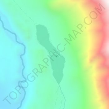
Nom : Carte topographique Chandratal Lake, altitude, relief.
Altitude moyenne : 4 403 m
Altitude minimum : 4 091 m
Altitude maximum : 5 168 m
Faire un don
Équipez-vous pour votre prochaine aventure :
En tant que Partenaire Amazon, ce site perçoit une commission sur les achats éligibles sans surcoût pour vous.
Autres cartes topographiques
Cliquez sur une carte pour visualiser sa topographie, son altitude et son relief.
Faire un don
Équipez-vous pour votre prochaine aventure :
En tant que Partenaire Amazon, ce site perçoit une commission sur les achats éligibles sans surcoût pour vous.
Faire un don
Équipez-vous pour votre prochaine aventure :
En tant que Partenaire Amazon, ce site perçoit une commission sur les achats éligibles sans surcoût pour vous.
Indrasan
India > Himachal Pradesh > Lahul
Mount Indrasan is located at an altitude of 6221 metres above sea level in Kullu district, Himachal Pradesh. Mt. Indrasan is considered as the most difficult mountain to climb in the Pir Panjal range of the Himalayas because of the challenges involved in scaling it. It was first climbed on October 13, 1962, by…
Altitude moyenne : 5 374 m
Darcha
India > Himachal Pradesh > Lahul
Darcha (elevation 3,360 m or 11,020 ft) is a pair of villages (Darcha Sumdo and Darach Dangma) on the Bhaga River in the Lahaul sub-division in the Lahaul and Spiti district in the Indian state of Himachal Pradesh. It is the northernmost permanent settlement in Himachal Pradesh along the Manali-Leh Highway.…
Altitude moyenne : 3 702 m
Faire un don
Équipez-vous pour votre prochaine aventure :
En tant que Partenaire Amazon, ce site perçoit une commission sur les achats éligibles sans surcoût pour vous.
Keylang
India > Himachal Pradesh > Lahul
Kyelang is accessible from Manali via the Manali-Leh Highway, a part of NH21. It is located about 71 km (44 mi) north of Manali at an altitude of 3,080 m (10,100 ft) and used to remain cut off from the outside world for six months from late October to mid-May due to heavy snowfall at Rohtang pass until the…
Altitude moyenne : 3 823 m
Darcha
India > Himachal Pradesh > Lahul
Darcha (elevation 3,360 m or 11,020 ft) is a pair of villages (Darcha Sumdo and Darach Dangma) on the Bhaga River in the Lahaul sub-division in the Lahaul and Spiti district in the Indian state of Himachal Pradesh. It is the northernmost permanent settlement in Himachal Pradesh along the Manali-Leh Highway.…
Altitude moyenne : 3 702 m