
Faire un don
Équipez-vous pour votre prochaine aventure :
En tant que Partenaire Amazon, ce site perçoit une commission sur les achats éligibles sans surcoût pour vous.
Carte topographique West Hartford
Cliquez sur la carte pour afficher l’altitude.
Faire un don
Équipez-vous pour votre prochaine aventure :
En tant que Partenaire Amazon, ce site perçoit une commission sur les achats éligibles sans surcoût pour vous.
West Hartford
The west side of West Hartford is flanked by the Metacomet Ridge, a mountainous trap rock ridgeline that stretches from Long Island Sound to nearly the Vermont border. Notable features of the Metacomet Ridge in West Hartford include Talcott Mountain and a number of highland water reservoirs belonging to the Metropolitan District, which maintains watershed and recreation resources on the property. The 51-mile-long (82 km) Metacomet Trail traverses the ridge. The town's web site indicates that the highest point in town is 778 feet (237 m) above sea level on Talcott (Avon) Mountain. The altitude at Town Hall is 120 feet (37 m).
Faire un don
Équipez-vous pour votre prochaine aventure :
En tant que Partenaire Amazon, ce site perçoit une commission sur les achats éligibles sans surcoût pour vous.
À propos de cette carte
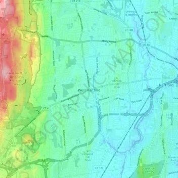
Nom : Carte topographique West Hartford, altitude, relief.
Altitude moyenne : 60 m
Altitude minimum : 9 m
Altitude maximum : 250 m
Faire un don
Équipez-vous pour votre prochaine aventure :
En tant que Partenaire Amazon, ce site perçoit une commission sur les achats éligibles sans surcoût pour vous.
Autres cartes topographiques
Cliquez sur une carte pour visualiser sa topographie, son altitude et son relief.
West Suffield
United States > Connecticut > Capitol Planning Region > Suffield
Altitude moyenne : 59 m
Plantsville
United States > Connecticut > Capitol Planning Region > Southington
Altitude moyenne : 57 m
Four Corners
United States > Connecticut > Capitol Planning Region > Terramuggus
Altitude moyenne : 143 m
Willington Hill
United States > Connecticut > Capitol Planning Region > Willington
Altitude moyenne : 197 m
Faire un don
Équipez-vous pour votre prochaine aventure :
En tant que Partenaire Amazon, ce site perçoit une commission sur les achats éligibles sans surcoût pour vous.
Griswoldville
United States > Connecticut > Capitol Planning Region > Wethersfield
Altitude moyenne : 34 m
Faire un don
Équipez-vous pour votre prochaine aventure :
En tant que Partenaire Amazon, ce site perçoit une commission sur les achats éligibles sans surcoût pour vous.
Chaffeeville
United States > Connecticut > Capitol Planning Region > Mansfield
Altitude moyenne : 133 m
West District
United States > Connecticut > Capitol Planning Region > Farmington
Altitude moyenne : 92 m
Talcott Mountain
United States > Connecticut > Capitol Planning Region > Bloomfield
Altitude moyenne : 152 m
Faire un don
Équipez-vous pour votre prochaine aventure :
En tant que Partenaire Amazon, ce site perçoit une commission sur les achats éligibles sans surcoût pour vous.
South Wethersfield
United States > Connecticut > Capitol Planning Region > Wethersfield > Griswoldville
Altitude moyenne : 22 m
Buckingham
United States > Connecticut > Capitol Planning Region > Glastonbury
Altitude moyenne : 131 m
North Coventry
United States > Connecticut > Capitol Planning Region > Coventry
Altitude moyenne : 195 m
Faire un don
Équipez-vous pour votre prochaine aventure :
En tant que Partenaire Amazon, ce site perçoit une commission sur les achats éligibles sans surcoût pour vous.
Talcott Mountain
United States > Connecticut > Capitol Planning Region > Bloomfield
Altitude moyenne : 152 m
Faire un don
Équipez-vous pour votre prochaine aventure :
En tant que Partenaire Amazon, ce site perçoit une commission sur les achats éligibles sans surcoût pour vous.
Holcomb Farm
United States > Connecticut > Capitol Planning Region > Granby > West Granby
Altitude moyenne : 116 m
Faire un don
Équipez-vous pour votre prochaine aventure :
En tant que Partenaire Amazon, ce site perçoit une commission sur les achats éligibles sans surcoût pour vous.
Johnson Hill
United States > Connecticut > Capitol Planning Region > West Hartford
Altitude moyenne : 34 m
Spoonville
United States > Connecticut > Capitol Planning Region > East Granby
Altitude moyenne : 62 m
Stafford Springs
United States > Connecticut > Capitol Planning Region > Stafford
Altitude moyenne : 200 m
Faire un don
Équipez-vous pour votre prochaine aventure :
En tant que Partenaire Amazon, ce site perçoit une commission sur les achats éligibles sans surcoût pour vous.
Cottage Grove
United States > Connecticut > Capitol Planning Region > Bloomfield
Altitude moyenne : 31 m
Barbara Drive
United States > Connecticut > Capitol Planning Region > Windsor Locks
Altitude moyenne : 39 m
Faire un don
Équipez-vous pour votre prochaine aventure :
En tant que Partenaire Amazon, ce site perçoit une commission sur les achats éligibles sans surcoût pour vous.
Faire un don
Équipez-vous pour votre prochaine aventure :
En tant que Partenaire Amazon, ce site perçoit une commission sur les achats éligibles sans surcoût pour vous.