
Carte topographique Lowell
Carte interactive
Cliquez sur la carte pour afficher l’altitude.
À propos de cette carte
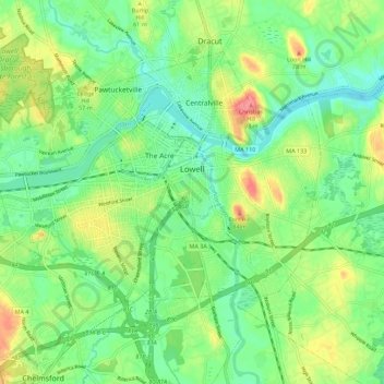
Nom : Carte topographique Lowell, altitude, relief.
Altitude moyenne : 42 m
Altitude minimum : 14 m
Altitude maximum : 105 m
Lowell is located at the confluence of the Merrimack and Concord rivers. The Pawtucket Falls, a mile-long set of rapids with a total drop in elevation of 32 feet, ends where the two rivers meet. At the top of the falls is the Pawtucket Dam, designed to turn the upper Merrimack into a millpond, diverted through Lowell's extensive canal system.