
Faire un don
Équipez-vous pour votre prochaine aventure :
En tant que Partenaire Amazon, ce site perçoit une commission sur les achats éligibles sans surcoût pour vous.
Carte topographique Christmas Island
Cliquez sur la carte pour afficher l’altitude.
Faire un don
Équipez-vous pour votre prochaine aventure :
En tant que Partenaire Amazon, ce site perçoit une commission sur les achats éligibles sans surcoût pour vous.
Christmas Island
Steep cliffs along much of the coast rise abruptly to a central plateau. Elevation ranges from sea level to 361 m (1,184 ft) at Murray Hill. The island is mainly tropical rainforest, 63% of which is national parkland. The narrow fringing reef surrounding the island poses a maritime hazard.
Faire un don
Équipez-vous pour votre prochaine aventure :
En tant que Partenaire Amazon, ce site perçoit une commission sur les achats éligibles sans surcoût pour vous.
À propos de cette carte
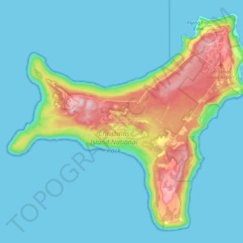
Nom : Carte topographique Christmas Island, altitude, relief.
Altitude moyenne : 69 m
Altitude minimum : 0 m
Altitude maximum : 363 m
Faire un don
Équipez-vous pour votre prochaine aventure :
En tant que Partenaire Amazon, ce site perçoit une commission sur les achats éligibles sans surcoût pour vous.