
Faire un don
Équipez-vous pour votre prochaine aventure :
En tant que Partenaire Amazon, ce site perçoit une commission sur les achats éligibles sans surcoût pour vous.
Carte topographique Bonito Lake
Cliquez sur la carte pour afficher l’altitude.
Faire un don
Équipez-vous pour votre prochaine aventure :
En tant que Partenaire Amazon, ce site perçoit une commission sur les achats éligibles sans surcoût pour vous.
À propos de cette carte
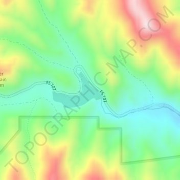
Nom : Carte topographique Bonito Lake, altitude, relief.
Lieu : Bonito Lake, Lincoln County, New Mexico, United States (33.45446 -105.74010 33.45978 -105.73091)
Altitude moyenne : 2 366 m
Altitude minimum : 2 194 m
Altitude maximum : 2 640 m
Faire un don
Équipez-vous pour votre prochaine aventure :
En tant que Partenaire Amazon, ce site perçoit une commission sur les achats éligibles sans surcoût pour vous.
Autres cartes topographiques
Cliquez sur une carte pour visualiser sa topographie, son altitude et son relief.
Ruidoso
United States > New Mexico > Lincoln County
Ruidoso is in southern Lincoln County, with elevations ranging from 6,400 feet (2,000 m) at the village's southeast corner in the valley of the Rio Ruidoso up to over 7,700 feet (2,300 m) at the village's northern end near Alto. Ruidoso's southern border and westernmost border follow the Otero County line. The…
Altitude moyenne : 2 287 m
Faire un don
Équipez-vous pour votre prochaine aventure :
En tant que Partenaire Amazon, ce site perçoit une commission sur les achats éligibles sans surcoût pour vous.
Alto
United States > New Mexico > Lincoln County
Alto is located at an elevation of 7,550 feet (2,300 m) in the Lincoln National Forest, five miles (8.0 km) north of the village of Ruidoso. Alto received its name from the Spanish word "high" because of its elevation.
Altitude moyenne : 2 285 m
Capitan
United States > New Mexico > Lincoln County
Capitan is a village in Lincoln County, New Mexico, United States, located north of the Lincoln National Forest between the Capitan and Sacramento Mountains at an elevation of 6,350 feet (1,950 m). The population was 1,489 at the 2010 census. Capitan was founded in the 1890s and incorporated in 1941.
Altitude moyenne : 1 986 m
Ruidoso
United States > New Mexico > Lincoln County
Ruidoso is in southern Lincoln County, with elevations ranging from 6,400 feet (2,000 m) at the village's southeast corner in the valley of the Rio Ruidoso up to over 7,700 feet (2,300 m) at the village's northern end near Alto. Ruidoso's southern border and westernmost border follow the Otero County line. The…
Altitude moyenne : 2 287 m
Faire un don
Équipez-vous pour votre prochaine aventure :
En tant que Partenaire Amazon, ce site perçoit une commission sur les achats éligibles sans surcoût pour vous.
Ruidoso
United States > New Mexico > Lincoln County
Ruidoso is in southern Lincoln County, with elevations ranging from 6,400 feet (2,000 m) at the village's southeast corner in the valley of the Rio Ruidoso up to over 7,700 feet (2,300 m) at the village's northern end near Alto. Ruidoso's southern border and westernmost border follow the Otero County line. The…
Altitude moyenne : 2 287 m
Carrizozo
United States > New Mexico > Lincoln County
To the west of the town is the Carrizozo Malpais, a 40-mile-long (64 km) lava flow that is about 1,500 years old and accessible through the Valley of Fires Recreation Area. To the northeast is Carrizo Mountain, a 9,600-foot (2,900 m) peak within the Sacramento Mountains, and to the southeast is the Sierra…
Altitude moyenne : 1 663 m
Faire un don
Équipez-vous pour votre prochaine aventure :
En tant que Partenaire Amazon, ce site perçoit une commission sur les achats éligibles sans surcoût pour vous.
Ruidoso
United States > New Mexico > Lincoln County
Ruidoso is in southern Lincoln County, with elevations ranging from 6,400 feet (2,000 m) at the village's southeast corner in the valley of the Rio Ruidoso up to over 7,700 feet (2,300 m) at the village's northern end near Alto. Ruidoso's southern border and westernmost border follow the Otero County line. The…
Altitude moyenne : 2 287 m
Alto
United States > New Mexico > Lincoln County
Alto is located at an elevation of 7,550 feet (2,300 m) in the Lincoln National Forest, five miles (8.0 km) north of the village of Ruidoso. Alto received its name from the Spanish word "high" because of its elevation.
Altitude moyenne : 2 285 m
Ruidoso
United States > New Mexico > Lincoln County
Ruidoso is in southern Lincoln County, with elevations ranging from 6,400 feet (2,000 m) at the village's southeast corner in the valley of the Rio Ruidoso up to over 7,700 feet (2,300 m) at the village's northern end near Alto. Ruidoso's southern border and westernmost border follow the Otero County line. The…
Altitude moyenne : 2 287 m
Faire un don
Équipez-vous pour votre prochaine aventure :
En tant que Partenaire Amazon, ce site perçoit une commission sur les achats éligibles sans surcoût pour vous.
Capitan
United States > New Mexico > Lincoln County
Capitan is a village in Lincoln County, New Mexico, United States, located north of the Lincoln National Forest between the Capitan and Sacramento Mountains at an elevation of 6,350 feet (1,950 m). The population was 1,489 at the 2010 census. Capitan was founded in the 1890s and incorporated in 1941.
Altitude moyenne : 1 986 m
Faire un don
Équipez-vous pour votre prochaine aventure :
En tant que Partenaire Amazon, ce site perçoit une commission sur les achats éligibles sans surcoût pour vous.