
Carte topographique Wolfeboro
Carte interactive
Cliquez sur la carte pour afficher l’altitude.
À propos de cette carte
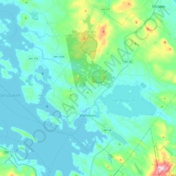
Nom : Carte topographique Wolfeboro, altitude, relief.
Lieu : Wolfeboro, Carroll County, New Hampshire, United States (43.53895 -71.28488 43.68028 -71.05920)
Altitude moyenne : 213 m
Altitude minimum : 149 m
Altitude maximum : 555 m
According to the United States Census Bureau, the town has a total area of 58.5 square miles (151.4 km2), of which 48.0 square miles (124.2 km2) are land and 10.5 square miles (27.2 km2) are water, comprising 17.95% of the town. Wolfeboro is drained by the Smith River, which is the outlet of Lake Wentworth and an inlet of Lake Winnipesaukee. Via Winnipesaukee, the town is part of the Merrimack River watershed. The highest point in town is Moody Mountain, elevation 1,420 feet (430 m) above sea level, located near the northern boundary.
Autres cartes topographiques
Cliquez sur une carte pour visualiser sa topographie, son altitude et son relief.
Cathedral Ledge
United States > New Hampshire > Carroll County > Bartlett
Cathedral Ledge, Bartlett, Carroll County, New Hampshire, 03845, United States
Altitude moyenne : 218 m
North Conway
United States > New Hampshire > Carroll County > Conway
North Conway, Conway, Carroll County, New Hampshire, 03860, United States
Altitude moyenne : 173 m
Conway
United States > New Hampshire > Carroll County
Conway, Carroll County, New Hampshire, United States
Altitude moyenne : 256 m
Big Attitash Mountain
United States > New Hampshire > Carroll County > Bartlett
Big Attitash Mountain, Bartlett, Carroll County, New Hampshire, United States
Altitude moyenne : 711 m
Eidelweiss Beach
United States > New Hampshire > Carroll County > Madison
Eidelweiss Beach, Madison, Carroll County, New Hampshire, United States
Altitude moyenne : 236 m
East Wakefield
United States > New Hampshire > Carroll County > Wakefield
East Wakefield, Wakefield, Carroll County, New Hampshire, 03830, United States
Altitude moyenne : 206 m
Brookfield
United States > New Hampshire > Carroll County
Brookfield, Carroll County, New Hampshire, United States
Altitude moyenne : 235 m
Center Conway
United States > New Hampshire > Carroll County > Conway
Center Conway, Conway, Carroll County, New Hampshire, 03813, United States
Altitude moyenne : 142 m
Kearsarge
United States > New Hampshire > Carroll County > Conway
Kearsarge, Conway, Carroll County, New Hampshire, 03847, United States
Altitude moyenne : 272 m
Albany
United States > New Hampshire > Carroll County
Albany, Carroll County, New Hampshire, United States
Altitude moyenne : 329 m
Melvin Village
United States > New Hampshire > Carroll County > Tuftonboro
Melvin Village, Tuftonboro, Carroll County, New Hampshire, 03850, United States
Altitude moyenne : 181 m
Ferncroft
United States > New Hampshire > Carroll County
Ferncroft, Albany, Carroll County, New Hampshire, 03897, United States
Altitude moyenne : 439 m
Center Sandwich
United States > New Hampshire > Carroll County > Sandwich
Center Sandwich, Sandwich, Carroll County, New Hampshire, 03227, United States
Altitude moyenne : 227 m
Lees Mill
United States > New Hampshire > Carroll County > Moultonborough
Lees Mill, Moultonborough, Carroll County, New Hampshire, 03254, United States
Altitude moyenne : 173 m
Wolfeboro Falls
United States > New Hampshire > Carroll County > Wolfeboro
Wolfeboro Falls, Wolfeboro, Carroll County, New Hampshire, 03894, United States
Altitude moyenne : 181 m
Union
United States > New Hampshire > Carroll County > Wakefield
Union, Wakefield, Carroll County, New Hampshire, 03887, United States
Altitude moyenne : 176 m
Center Ossipee
United States > New Hampshire > Carroll County > Ossipee
Center Ossipee, Ossipee, Carroll County, New Hampshire, 03814, United States
Altitude moyenne : 157 m
Chocorua
United States > New Hampshire > Carroll County > Tamworth
Chocorua, Tamworth, Carroll County, New Hampshire, 03817, United States
Altitude moyenne : 202 m
Redstone
United States > New Hampshire > Carroll County > Conway
Redstone, Conway, Carroll County, New Hampshire, 03860, United States
Altitude moyenne : 185 m
Silver Lake
United States > New Hampshire > Carroll County > Madison
Silver Lake, Madison, Carroll County, New Hampshire, United States
Altitude moyenne : 162 m
West Ossipee
United States > New Hampshire > Carroll County > Ossipee
West Ossipee, Ossipee, Carroll County, New Hampshire, 03890, United States
Altitude moyenne : 167 m
Hart's Location
United States > New Hampshire > Carroll County
Hart's Location, Carroll County, New Hampshire, United States
Altitude moyenne : 706 m
Wonalancet
United States > New Hampshire > Carroll County > Tamworth
Wonalancet, Tamworth, Carroll County, New Hampshire, 03897, United States
Altitude moyenne : 391 m
South Tamworth
United States > New Hampshire > Carroll County > Tamworth
South Tamworth, Tamworth, Carroll County, New Hampshire, 03883, United States
Altitude moyenne : 265 m
Ossipee
United States > New Hampshire > Carroll County
Ossipee, Carroll County, New Hampshire, United States
Altitude moyenne : 217 m
Flat Mountain
United States > New Hampshire > Carroll County > Sandwich
Flat Mountain, Sandwich, Carroll County, New Hampshire, United States
Altitude moyenne : 629 m
Lake Wentworth
United States > New Hampshire > Carroll County > Wolfeboro
Lake Wentworth, Wolfeboro, Carroll County, New Hampshire, United States
Altitude moyenne : 180 m
Ossipee Lake
United States > New Hampshire > Carroll County > Freedom
Ossipee Lake, Freedom, Carroll County, New Hampshire, United States
Altitude moyenne : 127 m
East Freedom
United States > New Hampshire > Carroll County > Freedom
East Freedom, Freedom, Carroll County, New Hampshire, United States
Altitude moyenne : 144 m
South Chatham
United States > New Hampshire > Carroll County > Chatham
South Chatham, Chatham, Carroll County, New Hampshire, United States
Altitude moyenne : 163 m
Mount Chocorua
United States > New Hampshire > Carroll County > Albany
Mount Chocorua, Albany, Carroll County, New Hampshire, United States
Altitude moyenne : 736 m
Sawyers River
United States > New Hampshire > Carroll County > Hart's Location
Sawyers River, Hart's Location, Carroll County, New Hampshire, United States
Altitude moyenne : 457 m
Wakefield
United States > New Hampshire > Carroll County
Wakefield, Carroll County, New Hampshire, United States
Altitude moyenne : 218 m
Moultonborough
United States > New Hampshire > Carroll County
Moultonborough, Carroll County, New Hampshire, United States
Altitude moyenne : 243 m
Goose Corner
United States > New Hampshire > Carroll County > Wolfeboro
Goose Corner, Wolfeboro, Carroll County, New Hampshire, 03984, United States
Altitude moyenne : 189 m
Glen
United States > New Hampshire > Carroll County > Bartlett
Glen, Bartlett, Carroll County, New Hampshire, 03838, United States
Altitude moyenne : 240 m
Sandwich
United States > New Hampshire > Carroll County
Sandwich, Carroll County, New Hampshire, 03259, United States
Altitude moyenne : 373 m
Mount Washington Valley
United States > New Hampshire > Carroll County > Conway > North Conway
Mount Washington Valley, North Conway, Conway, Carroll County, New Hampshire, 03860, United States
Altitude moyenne : 250 m
Tuftonboro
United States > New Hampshire > Carroll County
Tuftonboro, Carroll County, New Hampshire, United States
Altitude moyenne : 256 m
Bill Rae Conservation Area
United States > New Hampshire > Carroll County > Wolfeboro > Stockbridge Corner
Bill Rae Conservation Area, Stockbridge Corner, Wolfeboro, Carroll County, New Hampshire, United States
Altitude moyenne : 244 m
Brookfield
United States > New Hampshire > Carroll County > Brookfield
Brookfield, Carroll County, New Hampshire, 03872, United States
Altitude moyenne : 195 m
Mount Willard
United States > New Hampshire > Carroll County > Hart's Location
Mount Willard, Hart's Location, Carroll County, New Hampshire, United States
Altitude moyenne : 775 m
North Sandwich
United States > New Hampshire > Carroll County > Sandwich
North Sandwich, Sandwich, Carroll County, New Hampshire, 03259, United States
Altitude moyenne : 233 m
Sanbornville
United States > New Hampshire > Carroll County > Wakefield
Sanbornville, Wakefield, Carroll County, New Hampshire, 03872, United States
Altitude moyenne : 185 m
Thurley Mountain
United States > New Hampshire > Carroll County > Ossipee
Thurley Mountain, Ossipee, Carroll County, New Hampshire, United States
Altitude moyenne : 386 m
Eaton
United States > New Hampshire > Carroll County
Eaton, Carroll County, New Hampshire, 03832, United States
Altitude moyenne : 262 m
Thorn Hill
United States > New Hampshire > Carroll County > Bartlett
Thorn Hill, Bartlett, Carroll County, New Hampshire, 03838, United States
Altitude moyenne : 311 m
Mirror Lake
United States > New Hampshire > Carroll County > Tuftonboro > Mirror Lake
Mirror Lake, Tuftonboro, Carroll County, New Hampshire, United States
Altitude moyenne : 169 m
Intervale
United States > New Hampshire > Carroll County > Conway
Intervale, Conway, Carroll County, New Hampshire, 03845, United States
Altitude moyenne : 198 m
Crawford Notch State Park
United States > New Hampshire > Carroll County > Hart's Location
Crawford Notch State Park, Hart's Location, Carroll County, New Hampshire, United States
Altitude moyenne : 796 m