
Faire un don
Équipez-vous pour votre prochaine aventure :
En tant que Partenaire Amazon, ce site perçoit une commission sur les achats éligibles sans surcoût pour vous.
Carte topographique Scarborough
Cliquez sur la carte pour afficher l’altitude.
Faire un don
Équipez-vous pour votre prochaine aventure :
En tant que Partenaire Amazon, ce site perçoit une commission sur les achats éligibles sans surcoût pour vous.
Scarborough
According to the United States Census Bureau, the town has a total area of 70.63 square miles (182.93 km2), of which, 47.61 square miles (123.31 km2) is land and 23.02 square miles (59.62 km2) is water. Drained by the Scarborough River, Nonesuch River, Libby River and Spurwink River, the town is situated beside the Gulf of Maine, part of the Atlantic Ocean. The highest point is Beech Ridge, elevation 215 feet (66 m). In early years of Scarborough's settlement bonfires were set on Scottow Hill, elevation 144 feet (44 m), as warnings to the surrounding countryside of approaching danger.
Faire un don
Équipez-vous pour votre prochaine aventure :
En tant que Partenaire Amazon, ce site perçoit une commission sur les achats éligibles sans surcoût pour vous.
À propos de cette carte
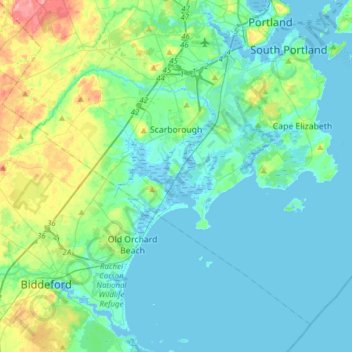
Nom : Carte topographique Scarborough, altitude, relief.
Lieu : Scarborough, Cumberland County, Maine, 04074, United States (43.46688 -70.49201 43.65578 -70.18424)
Altitude moyenne : 17 m
Altitude minimum : -5 m
Altitude maximum : 87 m
Faire un don
Équipez-vous pour votre prochaine aventure :
En tant que Partenaire Amazon, ce site perçoit une commission sur les achats éligibles sans surcoût pour vous.
Autres cartes topographiques
Cliquez sur une carte pour visualiser sa topographie, son altitude et son relief.
Cliff Island
United States > Maine > Cumberland County > Portland > Cliff Island
Altitude moyenne : 1 m
Faire un don
Équipez-vous pour votre prochaine aventure :
En tant que Partenaire Amazon, ce site perçoit une commission sur les achats éligibles sans surcoût pour vous.
Faire un don
Équipez-vous pour votre prochaine aventure :
En tant que Partenaire Amazon, ce site perçoit une commission sur les achats éligibles sans surcoût pour vous.