
Carte topographique Rahan
Cliquez sur la carte pour afficher l’altitude.
À propos de cette carte
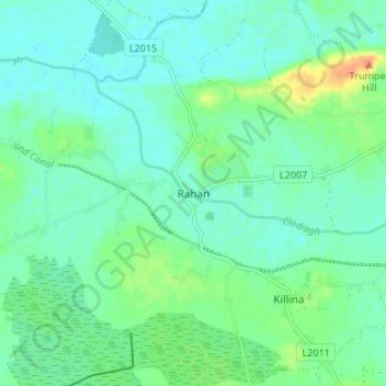
Nom : Carte topographique Rahan, altitude, relief.
Altitude moyenne : 53 m
Altitude minimum : 43 m
Altitude maximum : 81 m
Autres cartes topographiques
Cliquez sur une carte pour visualiser sa topographie, son altitude et son relief.
Banagher
There are more than twenty places in Ireland called Banagher or a version thereof. Banagher can be derived as the anglicised version of the Irish 'Beannchor' or 'Beannchar'. Most Irish placenames relate to topographical features and this is the case with 'Beannchor' - in this sense 'beann' refers to or means a…
Altitude moyenne : 44 m