
Carte topographique Morton
Carte interactive
Cliquez sur la carte pour afficher l’altitude.
À propos de cette carte
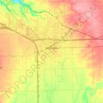
Nom : Carte topographique Morton, altitude, relief.
Lieu : Morton, Tazewell County, Illinois, 61550, United States (40.55614 -89.51667 40.66225 -89.42163)
Altitude moyenne : 219 m
Altitude minimum : 163 m
Altitude maximum : 260 m
Autres cartes topographiques
Cliquez sur une carte pour visualiser sa topographie, son altitude et son relief.
Washington
United States > Illinois > Tazewell County
Washington, Tazewell County, Illinois, 61571, United States
Altitude moyenne : 236 m
Deer Creek
United States > Illinois > Tazewell County
Deer Creek, Tazewell County, Illinois, United States
Altitude moyenne : 227 m
Green Valley
United States > Illinois > Tazewell County
Green Valley, Tazewell County, Illinois, United States
Altitude moyenne : 164 m
East Peoria
United States > Illinois > Tazewell County
East Peoria, Tazewell County, Illinois, 61611, United States
Altitude moyenne : 176 m
Tazewell County
United States > Illinois > Tazewell County
Tazewell County, Illinois, United States
Altitude moyenne : 190 m