
Faire un don
Équipez-vous pour votre prochaine aventure :
En tant que Partenaire Amazon, ce site perçoit une commission sur les achats éligibles sans surcoût pour vous.
Carte topographique Hometown
Cliquez sur la carte pour afficher l’altitude.
Faire un don
Équipez-vous pour votre prochaine aventure :
En tant que Partenaire Amazon, ce site perçoit une commission sur les achats éligibles sans surcoût pour vous.
Hometown
According to the United States Census Bureau, the CDP has a total area of 2.0 square miles (5.2 km2), all land. Hometown is located 2 miles (3.2 km) north of Tamaqua and 10 miles (16 km) south of Hazleton at the intersections of Route 54 and 309. Hometown's elevation is 1,129 feet (344 m) above sea level. It uses the Tamaqua zip code of 18252.
Faire un don
Équipez-vous pour votre prochaine aventure :
En tant que Partenaire Amazon, ce site perçoit une commission sur les achats éligibles sans surcoût pour vous.
À propos de cette carte
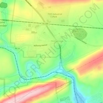
Nom : Carte topographique Hometown, altitude, relief.
Altitude moyenne : 352 m
Altitude minimum : 249 m
Altitude maximum : 481 m
Faire un don
Équipez-vous pour votre prochaine aventure :
En tant que Partenaire Amazon, ce site perçoit une commission sur les achats éligibles sans surcoût pour vous.