
Faire un don
Équipez-vous pour votre prochaine aventure :
En tant que Partenaire Amazon, ce site perçoit une commission sur les achats éligibles sans surcoût pour vous.
Carte topographique Roborough
Cliquez sur la carte pour afficher l’altitude.
Faire un don
Équipez-vous pour votre prochaine aventure :
En tant que Partenaire Amazon, ce site perçoit une commission sur les achats éligibles sans surcoût pour vous.
À propos de cette carte
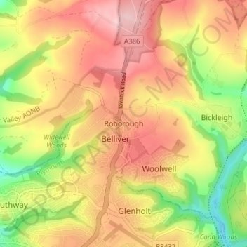
Nom : Carte topographique Roborough, altitude, relief.
Lieu : Roborough, South Hams, Devon, England, PL6 7BG, United Kingdom (50.42111 -4.12813 50.46111 -4.08813)
Altitude moyenne : 123 m
Altitude minimum : 22 m
Altitude maximum : 200 m
Faire un don
Équipez-vous pour votre prochaine aventure :
En tant que Partenaire Amazon, ce site perçoit une commission sur les achats éligibles sans surcoût pour vous.
Autres cartes topographiques
Cliquez sur une carte pour visualiser sa topographie, son altitude et son relief.
Ivybridge
United Kingdom > England > Devon > South Hams
The topography of Ivybridge is generally hilly. This is because of the River Erme which flows right through the centre of town. To the east and to the west of the river the land is elevated forming a valley. The river first enters the town at 300 feet (91 m) above sea level and leaves the town at 130 feet (40…
Altitude moyenne : 114 m
Faire un don
Équipez-vous pour votre prochaine aventure :
En tant que Partenaire Amazon, ce site perçoit une commission sur les achats éligibles sans surcoût pour vous.