
Carte topographique Allen County
Carte interactive
Cliquez sur la carte pour afficher l’altitude.
À propos de cette carte
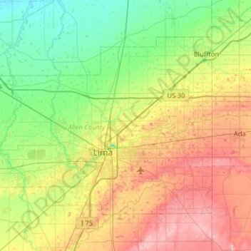
Nom : Carte topographique Allen County, altitude, relief.
Lieu : Allen County, Ohio, United States of America (40.64266 -84.39757 40.92043 -83.87984)
Altitude moyenne : 264 m
Altitude minimum : 221 m
Altitude maximum : 336 m
Autres cartes topographiques
Cliquez sur une carte pour visualiser sa topographie, son altitude et son relief.
Brecksville
United States of America > Ohio > Brecksville > Brecksville
Brecksville, Cuyahoga County, Ohio, 44141, United States of America
Altitude moyenne : 292 m
Scioto County
United States of America > Ohio
Scioto County, Ohio, United States of America
Altitude moyenne : 245 m
Summerland Beach
United States of America > Ohio > Millersport > Summerland Beach
Summerland Beach, Millersport, Fairfield, Ohio, 43046, United States of America
Altitude moyenne : 279 m
Gordon
United States of America > Ohio > Gordon
Gordon, Darke County, Ohio, United States of America
Altitude moyenne : 317 m
Pines Cottage Area
United States of America > Ohio > Pines Cottage Area
Pines Cottage Area, Orange Township, Carroll County, Ohio, 44639, United States of America
Altitude moyenne : 320 m
Crystal Park
United States of America > Ohio > Canton > Crystal Park
Crystal Park, Canton, Stark County, Ohio, 44705, United States of America
Altitude moyenne : 331 m
Graytown
United States of America > Ohio > Graytown
Graytown, Benton Township, Ottawa County, Ohio, 43432, United States of America
Altitude moyenne : 182 m
Fish Creek
United States of America > Ohio
Fish Creek, Franklin Township, Portage County, Ohio, 44240-1956, United States of America
Altitude moyenne : 325 m
New Miami
United States of America > Ohio > New Miami > New Miami
New Miami, St. Clair Township, Butler County, Ohio, United States of America
Altitude moyenne : 188 m