
Carte topographique Charlie Island
Carte interactive
Cliquez sur la carte pour afficher l’altitude.
À propos de cette carte
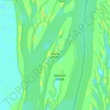
Nom : Carte topographique Charlie Island, altitude, relief.
Lieu : Charlie Island, Des Moines County, Iowa, USA (41.00173 -90.95953 41.02062 -90.94909)
Altitude moyenne : 166 m
Altitude minimum : 158 m
Altitude maximum : 175 m
Autres cartes topographiques
Cliquez sur une carte pour visualiser sa topographie, son altitude et son relief.
West Okoboji Lake
West Okoboji Lake, Fairfield Street, Okoboji, Dickinson County, Iowa, 51355, USA
Altitude moyenne : 437 m
Rathbun Lake
Rathbun Lake, 150th Avenue, Iconium, Appanoose County, Iowa, 52571, USA
Altitude moyenne : 292 m
Ballyclough
USA > Iowa > Ballyclough
Ballyclough, Dubuque County, Iowa, 52003, USA
Altitude moyenne : 281 m
Manikowski Prairie State Preserve
Manikowski Prairie State Preserve, 137th Street, Bryant, Clinton County, Iowa, 52750, USA
Altitude moyenne : 218 m
Cheever Lake
Cheever Lake, 190th Street, Raleigh, Emmet County, Iowa, 51334, USA
Altitude moyenne : 441 m
Saylorville Lake
Saylorville Lake, Lakeshore Trail, Andrews, Polk County, Iowa, USA
Altitude moyenne : 282 m
Anderson Prairie
Anderson Prairie, Ridge Road, Decorah, Winneshiek County, Iowa, 52101, USA
Altitude moyenne : 301 m
Pony Creek Lake
USA > Iowa > Pacific City
Pony Creek Lake, Deacon Road, Pacific Junction, Pacific City, Mills County, Iowa, 51561, USA
Altitude moyenne : 350 m
Malanaphy Springs State Preserve
Malanaphy Springs State Preserve, Winneshiek County, Iowa, USA
Altitude moyenne : 300 m
Calkin's Nature Area
Calkin's Nature Area, 135th Street, Hardin County, Iowa, 50126, USA
Altitude moyenne : 349 m
Lost Island Lake
Lost Island Lake, 340th Avenue, Palo Alto County, Iowa, 51358, USA
Altitude moyenne : 412 m
Lake Ahquabi
Lake Ahquabi, Nixon Street, Warren County, Iowa, 50125, USA
Altitude moyenne : 275 m
Beeds Lake
Beeds Lake, Beeds Lake Drive, Franklin County, Iowa, 50441, USA
Altitude moyenne : 351 m
Lake Red Rock
Lake Red Rock, 146th Avenue, Cordova, Marion County, Iowa, 50138, USA
Altitude moyenne : 248 m
Cayler Prairie State Preserve
Cayler Prairie State Preserve, Dickinson County, Iowa, USA
Altitude moyenne : 438 m
Ambrose A Call State Park
Ambrose A Call State Park, Hobarton, Kossuth County, Iowa, USA
Altitude moyenne : 364 m
Elinor Bedell State Park
Elinor Bedell State Park, Dickinson County, Iowa, USA
Altitude moyenne : 443 m
Randleman Lake
USA > Iowa > Woodland Hills
Randleman Lake, Backpacker Trail, Woodland Hills, Polk County, Iowa, 50047, USA
Altitude moyenne : 239 m
Lake Keomah
Lake Keomah, Keomah Lake Trail, Wright, Mahaska County, Iowa, USA
Altitude moyenne : 242 m
Kish-Ke-Kosh Prairie State Preserve
Kish-Ke-Kosh Prairie State Preserve, Robin Avenue, Reasnor, Jasper County, Iowa, 50232, USA
Altitude moyenne : 242 m
Lake Wapello
Lake Wapello, Access Trail, Blackhawk, Davis County, Iowa, USA
Altitude moyenne : 254 m
Margo Frankel Woods State Park
USA > Iowa > Saylorville
Margo Frankel Woods State Park, Northwest 2nd Street, Saylorville, Polk County, Iowa, 50023-9723, USA
Altitude moyenne : 273 m
Twin View Heights
USA > Iowa > Twin View Heights
Twin View Heights, Johnson County, Iowa, 52333, USA
Altitude moyenne : 221 m
Hartman Reserve Nature Center
Hartman Reserve Nature Center, Waterloo, Black Hawk County, Iowa, USA
Altitude moyenne : 270 m
Kuehn Conservation Area
Kuehn Conservation Area, Kennedy, Dallas County, Iowa, USA
Altitude moyenne : 294 m
East Okoboji Lake
East Okoboji Lake, Shoreline Drive, Dickinson County, Iowa, 51360, USA
Altitude moyenne : 448 m
Starr's Cave Nature Center
USA > Iowa > Green Acres Mobile Home Park
Starr's Cave Nature Center, West Burlington, Green Acres Mobile Home Park, Des Moines County, Iowa, 52601, USA
Altitude moyenne : 192 m