
Faire un don
Équipez-vous pour votre prochaine aventure :
En tant que Partenaire Amazon, ce site perçoit une commission sur les achats éligibles sans surcoût pour vous.
Carte topographique Forest Park
Cliquez sur la carte pour afficher l’altitude.
Faire un don
Équipez-vous pour votre prochaine aventure :
En tant que Partenaire Amazon, ce site perçoit une commission sur les achats éligibles sans surcoût pour vous.
Forest Park
Solidified lava from Grande Ronde members of the Columbia River Basalt Group underlie Forest Park. About 16 million years ago during the Middle Miocene, the Columbia River ran through a lowland south of its modern channel. Eruptions from linear vents in eastern Oregon and Washington flowed down this channel through what later became the Willamette Valley. These flows, some of which reached the Pacific Ocean, recurred at intervals between 16.5 and 15.6 million years ago and covered almost 60,000 square miles (160,000 km2). About eight separate Grande Ronde Basalt flows have been mapped in the Tualatin Mountains (West Hills), where they underlie the steepest slopes of Forest Park and form the columned rocks visible along Balch Creek Canyon and Northwest Cornell Road. The West Hills were later covered by wind-deposited silts that become unstable when saturated with water. Stream bank instability and siltation are common, and landslides deter urban development at higher elevations.
Faire un don
Équipez-vous pour votre prochaine aventure :
En tant que Partenaire Amazon, ce site perçoit une commission sur les achats éligibles sans surcoût pour vous.
À propos de cette carte
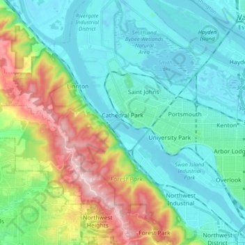
Nom : Carte topographique Forest Park, altitude, relief.
Altitude moyenne : 91 m
Altitude minimum : -8 m
Altitude maximum : 384 m
Faire un don
Équipez-vous pour votre prochaine aventure :
En tant que Partenaire Amazon, ce site perçoit une commission sur les achats éligibles sans surcoût pour vous.
Autres cartes topographiques
Cliquez sur une carte pour visualiser sa topographie, son altitude et son relief.
Powell Butte
United States > Oregon > Multnomah County > Portland
Powell Butte is located in Multnomah County in the U.S. state of Oregon. According to the U.S. National Geodetic Survey, the butte reaches an elevation of 614 feet (187 m), while the Geographic Names Information System lists the mountain's elevation at 627 feet (191 m). J.E. Allen, an emeritus professor of…
Altitude moyenne : 105 m
Faire un don
Équipez-vous pour votre prochaine aventure :
En tant que Partenaire Amazon, ce site perçoit une commission sur les achats éligibles sans surcoût pour vous.