
Carte topographique Osage County
Carte interactive
Cliquez sur la carte pour afficher l’altitude.
À propos de cette carte
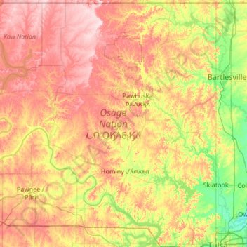
Nom : Carte topographique Osage County, altitude, relief.
Lieu : Osage County, Oklahoma, United States (36.16079 -97.06701 36.99929 -96.00046)
Altitude moyenne : 277 m
Altitude minimum : 175 m
Altitude maximum : 413 m
Holmes Peak is a mountain northwest of Tulsa in Osage County. It was named by the United States Board on Geographic Names on October 5, 1983 for the fictional detective, Sherlock Holmes. The name was proposed by Richard S. Warner. Holmes Peak is the highest point in the Tulsa Metropolitan area, with an elevation of 1,030 feet (310 m), though it ranks only as the 379th highest point in the state.
Autres cartes topographiques
Cliquez sur une carte pour visualiser sa topographie, son altitude et son relief.
Skiatook
United States > Oklahoma > Osage County
Skiatook, Osage County, Oklahoma, 74070, United States
Altitude moyenne : 222 m
Foraker
United States > Oklahoma > Osage County
Foraker, Osage County, Oklahoma, United States
Altitude moyenne : 385 m
Fairfax
United States > Oklahoma > Osage County
Fairfax, Osage County, Oklahoma, United States
Altitude moyenne : 259 m
Herd
United States > Oklahoma > Osage County
Herd, Osage County, Oklahoma, United States
Altitude moyenne : 287 m