
Faire un don
Équipez-vous pour votre prochaine aventure :
En tant que Partenaire Amazon, ce site perçoit une commission sur les achats éligibles sans surcoût pour vous.
Carte topographique Sweet Water Park
Cliquez sur la carte pour afficher l’altitude.
Faire un don
Équipez-vous pour votre prochaine aventure :
En tant que Partenaire Amazon, ce site perçoit une commission sur les achats éligibles sans surcoût pour vous.
À propos de cette carte
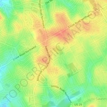
Nom : Carte topographique Sweet Water Park, altitude, relief.
Altitude moyenne : 292 m
Altitude minimum : 266 m
Altitude maximum : 312 m
Faire un don
Équipez-vous pour votre prochaine aventure :
En tant que Partenaire Amazon, ce site perçoit une commission sur les achats éligibles sans surcoût pour vous.
Autres cartes topographiques
Cliquez sur une carte pour visualiser sa topographie, son altitude et son relief.
Buford
United States > Georgia > Gwinnett County
Buford is located in both northern Gwinnett County in northern Georgia, with a small portion extending north into Hall County. The city is a suburb within the Atlanta metropolitan area. According to the United States Census Bureau, as of 2010 the city has a total land area of 17.09 square miles (44.26 km2), of…
Altitude moyenne : 340 m
Faire un don
Équipez-vous pour votre prochaine aventure :
En tant que Partenaire Amazon, ce site perçoit une commission sur les achats éligibles sans surcoût pour vous.
Faire un don
Équipez-vous pour votre prochaine aventure :
En tant que Partenaire Amazon, ce site perçoit une commission sur les achats éligibles sans surcoût pour vous.
Sugar Hill
United States > Georgia > Gwinnett County
According to the United States Census Bureau, as of 2010 the city of Sugar Hill had a total land area of 10.6 square miles (27.5 km2), of which 0.04 square miles (0.1 km2), or 0.33%, was water. The U.S. Geological Survey lists the city's elevation as 1,149 feet (350 m).
Altitude moyenne : 332 m
Snellville
United States > Georgia > Gwinnett County
Compared to most large cities around the world at approximately the same latitude (33°39'), such as Beirut, Casablanca, Dallas, Los Angeles, and Phoenix, Snellville has lower average winter temperatures. The primary reason for this is that the North American continent extends into high latitudes that allows…
Altitude moyenne : 300 m
Faire un don
Équipez-vous pour votre prochaine aventure :
En tant que Partenaire Amazon, ce site perçoit une commission sur les achats éligibles sans surcoût pour vous.
Snellville
United States > Georgia > Gwinnett County
Compared to most large cities around the world at approximately the same latitude (33°39'), such as Beirut, Casablanca, Dallas, Los Angeles, and Phoenix, Snellville has lower average winter temperatures. The primary reason for this is that the North American continent extends into high latitudes that allows…
Altitude moyenne : 300 m
Buford
United States > Georgia > Gwinnett County
Buford is located in both northern Gwinnett County in northern Georgia, with a small portion extending north into Hall County. The city is a suburb within the Atlanta metropolitan area. According to the United States Census Bureau, as of 2010 the city has a total land area of 17.09 square miles (44.26 km2), of…
Altitude moyenne : 340 m
Faire un don
Équipez-vous pour votre prochaine aventure :
En tant que Partenaire Amazon, ce site perçoit une commission sur les achats éligibles sans surcoût pour vous.
Faire un don
Équipez-vous pour votre prochaine aventure :
En tant que Partenaire Amazon, ce site perçoit une commission sur les achats éligibles sans surcoût pour vous.
Pine Ridge Country Club Estates
United States > Georgia > Gwinnett County > Lawrenceville
Altitude moyenne : 323 m
Faire un don
Équipez-vous pour votre prochaine aventure :
En tant que Partenaire Amazon, ce site perçoit une commission sur les achats éligibles sans surcoût pour vous.
Sugar Hill
United States > Georgia > Gwinnett County
According to the United States Census Bureau, as of 2010 the city of Sugar Hill had a total land area of 10.6 square miles (27.5 km2), of which 0.04 square miles (0.1 km2), or 0.33%, was water. The U.S. Geological Survey lists the city's elevation as 1,149 feet (350 m).
Altitude moyenne : 332 m
Faire un don
Équipez-vous pour votre prochaine aventure :
En tant que Partenaire Amazon, ce site perçoit une commission sur les achats éligibles sans surcoût pour vous.