
Faire un don
Équipez-vous pour votre prochaine aventure :
En tant que Partenaire Amazon, ce site perçoit une commission sur les achats éligibles sans surcoût pour vous.
Carte topographique Hohenaschau
Cliquez sur la carte pour afficher l’altitude.
Faire un don
Équipez-vous pour votre prochaine aventure :
En tant que Partenaire Amazon, ce site perçoit une commission sur les achats éligibles sans surcoût pour vous.
Hohenaschau
Aschach | Aschau im Chiemgau | Attich | Aufham | Außerkoy | Außerwald | Bach | Berg | Brückl | Bucha | Einfang | Engerndorf | Fellerer | Göttersberg | Grattenbach | Grenzhub | Grünwald | Hainbach | Haindorf | Hammerbach | Hintergschwendt | Hohenaschau im Chiemgau | Höhenberg | Hub | Huben | Innerkoy | Innerwald | Kohlstatt | Mitterleiten | Pölching | Reichenau | Sachrang | Schlechtenberg | Schoßrinn | Schwarzenstein | Schweibern | Seehaus | Spöck | Staffelstein | Stein | Vordergschwendt | Wald | Wasserthal | Weiher
Faire un don
Équipez-vous pour votre prochaine aventure :
En tant que Partenaire Amazon, ce site perçoit une commission sur les achats éligibles sans surcoût pour vous.
À propos de cette carte
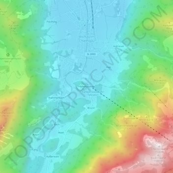
Nom : Carte topographique Hohenaschau, altitude, relief.
Altitude moyenne : 863 m
Altitude minimum : 597 m
Altitude maximum : 1 566 m
Faire un don
Équipez-vous pour votre prochaine aventure :
En tant que Partenaire Amazon, ce site perçoit une commission sur les achats éligibles sans surcoût pour vous.
Autres cartes topographiques
Cliquez sur une carte pour visualiser sa topographie, son altitude et son relief.
Bad Aibling
Deutschland > Bayern > Landkreis Rosenheim
Der schwere Eisenbahnunfall von Bad Aibling ereignete sich am 9. Februar 2016 gegen 7 Uhr auf Höhe des städtischen Klärwerks auf der Bahnstrecke Holzkirchen-Rosenheim. Es kollidierten frontal zwei Züge auf einer eingleisigen Strecke mit 12 Toten und über 17 Schwer- sowie 63 Leichtverletzten.
Altitude moyenne : 488 m
Stephanskirchen
Deutschland > Bayern > Landkreis Rosenheim
Von November 1944 bis April 1945 befand sich im Gemeindeteil Haidholzen das Außenlager Stephanskirchen des Konzentrationslagers Dachau, in dem etwa 250 KZ-Häftlinge Zwangsarbeit verrichten mussten. Die russischen, polnischen und französischen Kriegsgefangenen wurden in einer Barackensiedlung auf dem…
Altitude moyenne : 484 m
Faire un don
Équipez-vous pour votre prochaine aventure :
En tant que Partenaire Amazon, ce site perçoit une commission sur les achats éligibles sans surcoût pour vous.
Faire un don
Équipez-vous pour votre prochaine aventure :
En tant que Partenaire Amazon, ce site perçoit une commission sur les achats éligibles sans surcoût pour vous.
Aschau im Chiemgau
Deutschland > Bayern > Landkreis Rosenheim
Aschach | Aschau im Chiemgau | Attich | Aufham | Außerkoy | Außerwald | Bach | Berg | Brückl | Bucha | Einfang | Engerndorf | Fellerer | Göttersberg | Grattenbach | Grenzhub | Grünwald | Hainbach | Haindorf | Hammerbach | Hintergschwendt | Hohenaschau im Chiemgau | Höhenberg | Hub | Huben | Innerkoy |…
Altitude moyenne : 957 m
Faire un don
Équipez-vous pour votre prochaine aventure :
En tant que Partenaire Amazon, ce site perçoit une commission sur les achats éligibles sans surcoût pour vous.
Brannenburg
Deutschland > Bayern > Landkreis Rosenheim
Blick von der Biber Richtung Wendelstein – rechts auf halber Höhe St. Margarethen
Altitude moyenne : 678 m
Samerberg
Deutschland > Bayern > Landkreis Rosenheim
Die Gemeindeteile von Samerberg, einer ländlichen Region des Chiemgauer Voralpenlandes mit einer Reihe von Weilern und Einödhöfen, liegen östlich des Inns und östlich von Neubeuern räumlich weit verstreut auf einem hügeligen Hochplateau, das im Südosten von einer Bergkette, der Hochriesgruppe (von…
Altitude moyenne : 861 m
Faire un don
Équipez-vous pour votre prochaine aventure :
En tant que Partenaire Amazon, ce site perçoit une commission sur les achats éligibles sans surcoût pour vous.
Faire un don
Équipez-vous pour votre prochaine aventure :
En tant que Partenaire Amazon, ce site perçoit une commission sur les achats éligibles sans surcoût pour vous.
Schonstett
Deutschland > Bayern > Landkreis Rosenheim
Der Codex diplomaticus Falkensteinensis erwähnt Schonstett als Sconsteten, später auch als Sconstet, in späteren Dokumenten des Klosters Herrenchiemsee aus dem 12. Jahrhundert findet sich Schônstete. Im hohen Mittelalter waren die Herren von Schonstett Dienstmannen der Hallgrafen von Wasserburg am Inn. In…
Altitude moyenne : 477 m
Gstadt am Chiemsee
Deutschland > Bayern > Landkreis Rosenheim > Gstadt am Chiemsee
Altitude moyenne : 529 m
Faire un don
Équipez-vous pour votre prochaine aventure :
En tant que Partenaire Amazon, ce site perçoit une commission sur les achats éligibles sans surcoût pour vous.
Faire un don
Équipez-vous pour votre prochaine aventure :
En tant que Partenaire Amazon, ce site perçoit une commission sur les achats éligibles sans surcoût pour vous.
83071
Deutschland > Bayern > Landkreis Rosenheim > Stephanskirchen > Schömering
Altitude moyenne : 486 m
Faire un don
Équipez-vous pour votre prochaine aventure :
En tant que Partenaire Amazon, ce site perçoit une commission sur les achats éligibles sans surcoût pour vous.
Faire un don
Équipez-vous pour votre prochaine aventure :
En tant que Partenaire Amazon, ce site perçoit une commission sur les achats éligibles sans surcoût pour vous.
Stettner See
Deutschland > Bayern > Landkreis Rosenheim > Rimsting Bahnhof > Aiterbach
Altitude moyenne : 536 m
Faire un don
Équipez-vous pour votre prochaine aventure :
En tant que Partenaire Amazon, ce site perçoit une commission sur les achats éligibles sans surcoût pour vous.
Rohrdorf
Deutschland > Bayern > Landkreis Rosenheim
Erstmals urkundlich erwähnt wurde Rohrdorf 788 in der Notitia Arnonis, einer Aufstellung aller Güter und Besitzungen der Kirche Salzburg auf herzoglich-bayerischem Gebiet anlässlich der Eingliederung Bayerns in das Frankenreich Karls des Großen. Darin genannt sind auch die beiden heute eingemeindeten…
Altitude moyenne : 501 m
Happinger See
Deutschland > Bayern > Landkreis Rosenheim > Rosenheim > Pfraundorf
Altitude moyenne : 451 m
Faire un don
Équipez-vous pour votre prochaine aventure :
En tant que Partenaire Amazon, ce site perçoit une commission sur les achats éligibles sans surcoût pour vous.
Nußdorf am Inn
Deutschland > Bayern > Landkreis Rosenheim
Das in Nußdorf herrschende Mikroklima lässt sich durch seine Lage an einer Engstelle des Inntals sowie der Höhenlage von 486 Metern über dem Meeresspiegel erklären. Ebenfalls einen wichtigen Einfluss nimmt der „Erler Wind“, ein starker orographischer Fallwind, der in der Nacht einsetzt und meist am…
Altitude moyenne : 659 m
Wasserburg am Inn
Deutschland > Bayern > Landkreis Rosenheim
Entsprechend der geringen Höhe des angeschwemmten Landes gegenüber dem starken Schwankungen unterliegenden Wasserspiegel des Inns wurden weite Teile der Altstadt bei Hochwasser regelmäßig unter Wasser gesetzt, bis dies durch den Bau der Hochwasserfreilegung 1986 bislang unterbunden werden konnte.
Altitude moyenne : 474 m
Faire un don
Équipez-vous pour votre prochaine aventure :
En tant que Partenaire Amazon, ce site perçoit une commission sur les achats éligibles sans surcoût pour vous.
Albaching
Deutschland > Bayern > Landkreis Rosenheim
Der Jahresniederschlag liegt bei 1039 mm und ist damit vergleichsweise hoch, da er in das obere Viertel der in Deutschland erfassten Werte fällt. An 87 % der Messstationen des Deutschen Wetterdienstes werden niedrigere Werte registriert. Der trockenste Monat ist der Februar, die meisten Niederschläge fallen…
Altitude moyenne : 517 m
Faire un don
Équipez-vous pour votre prochaine aventure :
En tant que Partenaire Amazon, ce site perçoit une commission sur les achats éligibles sans surcoût pour vous.
Schechen
Deutschland > Bayern > Landkreis Rosenheim
Im Jahr 2022 erzielte Schechen Einnahmen aus der Gewerbesteuer in Höhe von 3,7 Millionen Euro. Mit einem Gewerbesteuerhebesatz von 330 % zählt die Gemeinde zu den steuerlich attraktiven Standorten Deutschlands. Schechen ist etwa steuerlich deutlich günstiger als die Landeshauptstadt München…
Altitude moyenne : 468 m
Feldkirchen-Westerham
Deutschland > Bayern > Landkreis Rosenheim
Feldkirchen-Westerham ist eine Gemeinde im oberbayerischen Landkreis Rosenheim, die aus den Gemeinden Vagen/Westerham, Feldkirchen und Höhenrain gebildet wurde.
Altitude moyenne : 599 m
Faire un don
Équipez-vous pour votre prochaine aventure :
En tant que Partenaire Amazon, ce site perçoit une commission sur les achats éligibles sans surcoût pour vous.
Mangfall
Deutschland > Bayern > Landkreis Rosenheim
Die größten Zuflüsse der Mangfall sind die Schlierach, die Leitzach, die Glonn und der Kaltenbach (Kalten). Zusätzlich wird die Mangfall noch von zahlreichen kleinen Zuflüssen, aber auch von Quellzuflüssen (besonders oberhalb des Mangfallknies) gespeist. Zu den weiteren Zuflüssen gehören der…
Altitude moyenne : 669 m
Herreninsel
Deutschland > Bayern > Landkreis Rosenheim > Chiemsee
Ein etwa acht Kilometer langer Rundweg führt in Ufernähe um die Insel. An der südwestlichen Ecke steigt der Weg zum Aussichtspunkt „Ottos Ruh“ mit einem pilzartigen Unterstand auf bis zu 20 Höhenmeter über dem See und fällt dann zur südwestlichen Ecke mit dem Aussichtspunkt „Pauls Ruh“ auf Seeniveau wieder ab.
Altitude moyenne : 520 m
Faire un don
Équipez-vous pour votre prochaine aventure :
En tant que Partenaire Amazon, ce site perçoit une commission sur les achats éligibles sans surcoût pour vous.
Faire un don
Équipez-vous pour votre prochaine aventure :
En tant que Partenaire Amazon, ce site perçoit une commission sur les achats éligibles sans surcoût pour vous.
83229
Deutschland > Bayern > Landkreis Rosenheim > Aschau im Chiemgau > Schoßrinn
Altitude moyenne : 904 m
Faire un don
Équipez-vous pour votre prochaine aventure :
En tant que Partenaire Amazon, ce site perçoit une commission sur les achats éligibles sans surcoût pour vous.
Brannenburg
Deutschland > Bayern > Landkreis Rosenheim
Blick von der Biber Richtung Wendelstein – rechts auf halber Höhe St. Margarethen
Altitude moyenne : 678 m
Aschau im Chiemgau
Deutschland > Bayern > Landkreis Rosenheim
Aschach | Aschau im Chiemgau | Attich | Aufham | Außerkoy | Außerwald | Bach | Berg | Brückl | Bucha | Einfang | Engerndorf | Fellerer | Göttersberg | Grattenbach | Grenzhub | Grünwald | Hainbach | Haindorf | Hammerbach | Hintergschwendt | Hohenaschau im Chiemgau | Höhenberg | Hub | Huben | Innerkoy |…
Altitude moyenne : 957 m
Faire un don
Équipez-vous pour votre prochaine aventure :
En tant que Partenaire Amazon, ce site perçoit une commission sur les achats éligibles sans surcoût pour vous.
Samerberg
Deutschland > Bayern > Landkreis Rosenheim
Die Gemeindeteile von Samerberg, einer ländlichen Region des Chiemgauer Voralpenlandes mit einer Reihe von Weilern und Einödhöfen, liegen östlich des Inns und östlich von Neubeuern räumlich weit verstreut auf einem hügeligen Hochplateau, das im Südosten von einer Bergkette, der Hochriesgruppe (von…
Altitude moyenne : 861 m
Aschau im Chiemgau
Deutschland > Bayern > Landkreis Rosenheim
Aschach | Aschau im Chiemgau | Attich | Aufham | Außerkoy | Außerwald | Bach | Berg | Brückl | Bucha | Einfang | Engerndorf | Fellerer | Göttersberg | Grattenbach | Grenzhub | Grünwald | Hainbach | Haindorf | Hammerbach | Hintergschwendt | Hohenaschau im Chiemgau | Höhenberg | Hub | Huben | Innerkoy |…
Altitude moyenne : 957 m
Faire un don
Équipez-vous pour votre prochaine aventure :
En tant que Partenaire Amazon, ce site perçoit une commission sur les achats éligibles sans surcoût pour vous.
Rohrdorf
Deutschland > Bayern > Landkreis Rosenheim
Erstmals urkundlich erwähnt wurde Rohrdorf 788 in der Notitia Arnonis, einer Aufstellung aller Güter und Besitzungen der Kirche Salzburg auf herzoglich-bayerischem Gebiet anlässlich der Eingliederung Bayerns in das Frankenreich Karls des Großen. Darin genannt sind auch die beiden heute eingemeindeten…
Altitude moyenne : 501 m