
Carte topographique Katra
Carte interactive
Cliquez sur la carte pour afficher l’altitude.
À propos de cette carte
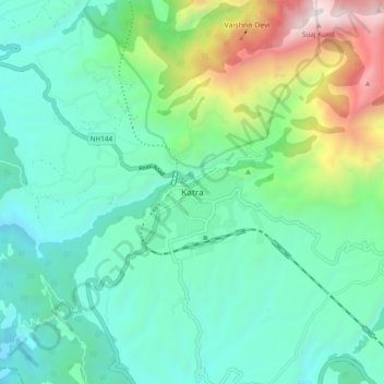
Nom : Carte topographique Katra, altitude, relief.
Lieu : Katra, Reasi, Reasi district, Jammu and Kashmir, 182301, India (32.95249 74.89181 33.03249 74.97181)
Altitude moyenne : 993 m
Altitude minimum : 465 m
Altitude maximum : 2 651 m
Katra is located at 32°59′N 74°57′E / 32.98°N 74.95°E / 32.98; 74.95. It has an average elevation of 875 metres (2,474 feet). The Banganga River passes through the village.
Autres cartes topographiques
Cliquez sur une carte pour visualiser sa topographie, son altitude et son relief.
Vaishno Devi
India > Jammu and Kashmir > Reasi > Vaishno Devi
Vaishno Devi, Reasi, Reasi district, Jammu and Kashmir, 182301, India
Altitude moyenne : 1 706 m