
Faire un don
Équipez-vous pour votre prochaine aventure :
En tant que Partenaire Amazon, ce site perçoit une commission sur les achats éligibles sans surcoût pour vous.
Carte topographique Baseline
Cliquez sur la carte pour afficher l’altitude.
Faire un don
Équipez-vous pour votre prochaine aventure :
En tant que Partenaire Amazon, ce site perçoit une commission sur les achats éligibles sans surcoût pour vous.
À propos de cette carte
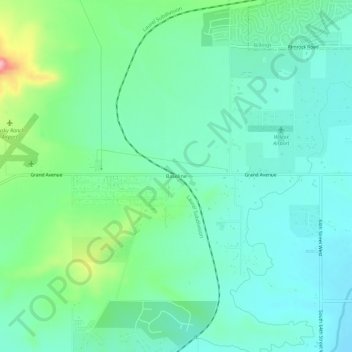
Nom : Carte topographique Baseline, altitude, relief.
Altitude moyenne : 1 043 m
Altitude minimum : 1 005 m
Altitude maximum : 1 161 m
Faire un don
Équipez-vous pour votre prochaine aventure :
En tant que Partenaire Amazon, ce site perçoit une commission sur les achats éligibles sans surcoût pour vous.
Autres cartes topographiques
Cliquez sur une carte pour visualiser sa topographie, son altitude et son relief.
Billings
United States > Montana > Yellowstone County
Two-thirds of the city is in the Yellowstone Valley and the South Hills area and one-third in the Heights-Lockwood area. The city is divided by the Rims, long cliffs, also called the Rimrocks. The Rims run to the north and east of the downtown core, separating it from the Heights to the north and Lockwood to…
Altitude moyenne : 1 023 m
Faire un don
Équipez-vous pour votre prochaine aventure :
En tant que Partenaire Amazon, ce site perçoit une commission sur les achats éligibles sans surcoût pour vous.
Billings
United States > Montana > Yellowstone County
Two-thirds of the city is in the Yellowstone Valley and the South Hills area and one-third in the Heights-Lockwood area. The city is divided by the Rims, long cliffs, also called the Rimrocks. The Rims run to the north and east of the downtown core, separating it from the Heights to the north and Lockwood to…
Altitude moyenne : 1 023 m